IMAGES TAKEN NEAR TO
Castle Gate, NOTTINGHAM, NG1 7AW
Introduction
This page details the photographs taken nearby to Castle Gate, NG1 7AW by members of the Geograph project.
The Geograph project started in 2005 with the aim of publishing, organising and preserving representative images for every square kilometre of Great Britain, Ireland and the Isle of Man.

There are currently over 7.5m images from over14,400 individuals and you can help contribute to the project by visiting https://www.geograph.org.uk
Image Map
Images are licensed for reuse under creativecommons.org/licenses/by-sa/2.0
Notes
- Clicking on the map will re-center to the selected point.
- The higher the marker number, the further away the image location is from the centre of the postcode.
Image Listing (2224 Images Found)
Images are licensed for reuse under creativecommons.org/licenses/by-sa/2.0
Image
Details
Distance
1
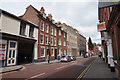
Rodney House, Hounds Gate, Nottingham
A 1970s office block.
One tenant was Notts Housing Advice.
Image: © Stephen Richards
Taken: 18 Jun 2012
0.01 miles
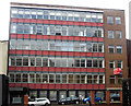
2
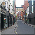
Warehouses, Hounds Gate, Nottingham
That on the right by Evans & Jolley, 1894-95, joined by a bridge, by Brewill & Baily, 1920-21, to more warehousing, probably by Thomas Wright and probably a little earlier.
A slightly different perspective: Image
Image: © Stephen Richards
Taken: 18 Jun 2012
0.01 miles
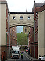
3
In Hounds Gate
The bridge connecting former warehouses has recently been repainted. For comparison, see Image
Image: © John Sutton
Taken: 6 Jul 2016
0.01 miles
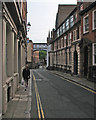
4
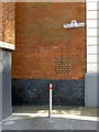
Truswell Yard, Nottingham
The 'yard' is a narrow alley http://www.geograph.org.uk/photo/6109245 leading off to the left. The name sign is in the style created by the City Council for the historic centre of the city during the late 20th century.
Image: © Alan Murray-Rust
Taken: 1 Apr 2019
0.02 miles
5
Castle Gate, Nottingham NG1
With Hounds Gate a few metres behind the photographer, this is the view from Truswell Yard (originally Truswell’s Yard) across Castle Gate and looking down Stanford Street. In yesteryear - apparently - there existed a brook in this vicinity called The Rowell. It seems to have trickled down from the high ground where Park Street now stands and eventually found its way into The Leen. At least one amateur historian has, it seems, wondered whether it used to trickle down through Truswell's Yard?
Image: © David Hallam-Jones
Taken: 5 Nov 2017
0.02 miles
6
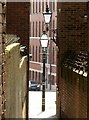
Truswell Yard, Nottingham
Looking down towards Castle Gate and Stanford Street. The old style street lamps - probably both modern - lend character to the scene.
Image: © Alan Murray-Rust
Taken: 1 Apr 2019
0.02 miles
7
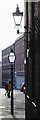
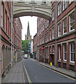
Nottingham - NG1 (Hounds Gate)
The present day narrowness of Hounds Gate (or Hungate as it was previously known), seen here with St Peter’s Gate and St Peter’s Church in the distance, gives observers some idea of what the street might have looked like in medieval times. Indeed the closeness of the buildings at one point must have made it relatively easy to construct the overhead weatherproof interconnecting corridor with its “Bridge of Sighs” appearance. The bridge itself, connecting the two portions of a former soft-goods warehouse, was constructed in 1923.
Image: © David Hallam-Jones
Taken: 18 May 2012
0.02 miles
8
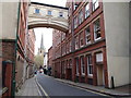
Hounds Gate
In shadow early on a May evening. The distinctive bridge built to link two warehouses dates from the 1920s.
Image: © John Sutton
Taken: 15 May 2013
0.02 miles
9
Hounds Gate and St Peter's spire
The bridge linking the third floors of these lace warehouses was added in the 1920s. It would have been good to have taken this picture on a bright evening rather than a dull September morning. Image] is the view towards here.
Image: © John Sutton
Taken: 26 Sep 2013
0.02 miles