IMAGES TAKEN NEAR TO
Canal Street, NOTTINGHAM, NG1 7AU
Introduction
This page details the photographs taken nearby to Canal Street, NG1 7AU by members of the Geograph project.
The Geograph project started in 2005 with the aim of publishing, organising and preserving representative images for every square kilometre of Great Britain, Ireland and the Isle of Man.

There are currently over 7.5m images from over14,400 individuals and you can help contribute to the project by visiting https://www.geograph.org.uk
Image Map
Images are licensed for reuse under creativecommons.org/licenses/by-sa/2.0
Notes
- Clicking on the map will re-center to the selected point.
- The higher the marker number, the further away the image location is from the centre of the postcode.
Image Listing (1476 Images Found)
Images are licensed for reuse under creativecommons.org/licenses/by-sa/2.0
Image
Details
Distance
1
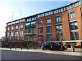
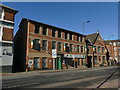
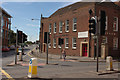
Land Registry offices, Nottingham
A modern building, one of fourteen holding land ownership records for England.
Image: © Stephen Craven
Taken: 18 Jan 2020
0.01 miles
2
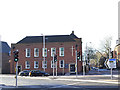
Grace Church, Nottingham (1)
Occupying the former Labour Exchange Image, this is now one of a chain of evangelical city churches.
Image: © Stephen Craven
Taken: 18 Jan 2020
0.02 miles
3

Benchmark on the Gracechurch Building, Castle Boulevard
Ordnance Survey cut mark benchmark described on the Bench Mark Database at http://www.bench-marks.org.uk/bm34404
Image: © Roger Templeman
Taken: 8 Apr 2012
0.02 miles
4
Gracechurch, Wilford Street
There is an OS benchmark Image on the facing right hand corner of the building which stands at the Wilford Street/Castle Boulevard junction
Image: © Roger Templeman
Taken: 8 Apr 2012
0.02 miles
5
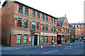
Irish Centre, Wilford Street, Nottingham
Image: © Stephen Craven
Taken: 18 Jan 2020
0.02 miles
6

Cut Bench Mark, Grace Church
Bench Mark Database: http://www.bench-marks.org.uk/bm34404
Image: © Mark Anderson
Taken: 9 Aug 2012
0.02 miles
7
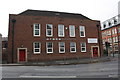
Grace Church, Nottingham
There is a cut bench mark to the right of the red door and a closer view can be seen here: Image
Image: © Mark Anderson
Taken: 9 Aug 2012
0.02 miles
8
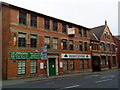
Nottingham Irish Centre
On Wilford Road.
In the late 1970s when the IRA was still in the habit of planting bombs on the British mainland a fellow student of mine ran a mobile disco, he was studying mining engineering and took holiday jobs in the Nottinghamshire coalfield. I am not sure how it came about but one night he had a booking here at the Irish Centre and I helped him with the set-up.
We were on our second or third trip up the stairs and carrying his boxes of 6" singles, when he suddenly stopped in front of me and I nearly fell over him.
"What's up?" I said.
"Where are we?" said he.
"The Irish Centre"
"What does it say on these boxes?"
I looked for the first time at the markings on these boxes I was carrying, so well sized for singles that I had never thought that they might have been designed to carry anything else.
"Nobel Explosives" I said.
Image: © David Lally
Taken: 19 Apr 2009
0.03 miles
10
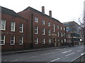
Grace Church Nottingham
The former Ministry of Labour Employment Exchange Building Nottingham now forms part of a church.
In November 2009, the church bought the former Ministry of Labour, Employment Exchange building on Castle Boulevard and renamed it 'The Ministry', a name which encompassed the heart of the church for the city.
Image: © Richard Hoare
Taken: 7 Feb 2012
0.03 miles