IMAGES TAKEN NEAR TO
Dorchester Road, NOTTINGHAM, NG17 9DL
Introduction
This page details the photographs taken nearby to Dorchester Road, NG17 9DL by members of the Geograph project.
The Geograph project started in 2005 with the aim of publishing, organising and preserving representative images for every square kilometre of Great Britain, Ireland and the Isle of Man.

There are currently over 7.5m images from over14,400 individuals and you can help contribute to the project by visiting https://www.geograph.org.uk
Image Map
Images are licensed for reuse under creativecommons.org/licenses/by-sa/2.0
Notes
- Clicking on the map will re-center to the selected point.
- The higher the marker number, the further away the image location is from the centre of the postcode.
Image Listing (10 Images Found)
Images are licensed for reuse under creativecommons.org/licenses/by-sa/2.0
Image
Details
Distance
1
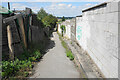
Footpath at Nuncargate
The path passes behind the back of houses on each side, and certainly existed before the houses to the right were built.
Image: © Bill Boaden
Taken: 3 Aug 2022
0.06 miles
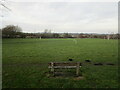
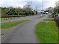
2
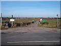
Annesley Woodhouse NG17, Notts.
This combined farm track, bridleway and public footpath - off Nuncargate Road - leads to Grives Farm and beyond it to the "Top Car Park" of Portland Park Nature Reserve, a "Site of Special Scientific Interest".
Image: © David Hallam-Jones
Taken: 28 Feb 2013
0.11 miles
3
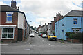
Fishers Street
One of several parallel roads off Nuncargate Road.
Image: © Bill Boaden
Taken: 3 Aug 2022
0.16 miles
4
Annesley Woodhouse - terrace on Nuncargate Road
Image: © Dave Bevis
Taken: 16 Feb 2013
0.18 miles
5
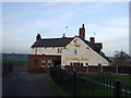
The Cricketer's Arms, Nuncargate
Harold Larwood lived and began playing cricket nearby. Lots of memorabilia is featured in the pub.
Image: © JThomas
Taken: 27 Dec 2016
0.19 miles
7
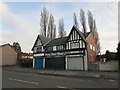
Commercial premises, Nuncargate Road
Image: © Jonathan Thacker
Taken: 29 Dec 2019
0.20 miles
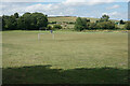
9
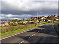
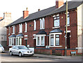
Near Shoulder of Mutton Hill
Older houses relating to the earlier mining industry mixed with later 20th century commuter-style development.
Image: © Alan Murray-Rust
Taken: 30 Nov 2014
0.23 miles
10
Shoulder of Mutton Hill
A sharp rise up to the ridge forming Robin Hood's Hills
Image: © Alan Murray-Rust
Taken: 30 Nov 2014
0.25 miles