IMAGES TAKEN NEAR TO
Midfield Road, NOTTINGHAM, NG17 9BZ
Introduction
This page details the photographs taken nearby to Midfield Road, NG17 9BZ by members of the Geograph project.
The Geograph project started in 2005 with the aim of publishing, organising and preserving representative images for every square kilometre of Great Britain, Ireland and the Isle of Man.

There are currently over 7.5m images from over14,400 individuals and you can help contribute to the project by visiting https://www.geograph.org.uk
Image Map
Images are licensed for reuse under creativecommons.org/licenses/by-sa/2.0
Notes
- Clicking on the map will re-center to the selected point.
- The higher the marker number, the further away the image location is from the centre of the postcode.
Image Listing (18 Images Found)
Images are licensed for reuse under creativecommons.org/licenses/by-sa/2.0
Image
Details
Distance
1
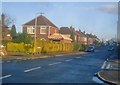
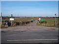
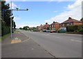
Seagrave Avenue
Looking east off the main Derby Road, which has another section running parallel to it - left and right off this picture.
Image: © Trevor Rickard
Taken: 24 Oct 2009
0.14 miles
2
Looking down Shoulder of Mutton Hill
A sharp rise up to the ridge forming Robin Hood's Hills. Behind the camera the land falls away again even more steeply.
Image: © Alan Murray-Rust
Taken: 30 Nov 2014
0.17 miles
3
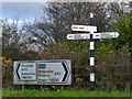
Fingerpost at Shoulder of Mutton Hill
Notts C C octagonal concrete post with slotted arms and octagonal cast-iron finial. An unusual survivor at a junction of classified roads, still standing alongside its modern counterpart.
Image: © Alan Murray-Rust
Taken: 30 Nov 2014
0.17 miles
4
Shoulder of Mutton Hill
A sharp rise up to the ridge forming Robin Hood's Hills
Image: © Alan Murray-Rust
Taken: 30 Nov 2014
0.17 miles
5
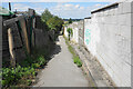
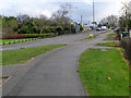
Footpath at Nuncargate
The path passes behind the back of houses on each side, and certainly existed before the houses to the right were built.
Image: © Bill Boaden
Taken: 3 Aug 2022
0.17 miles
6
Near Shoulder of Mutton Hill
Older houses relating to the earlier mining industry mixed with later 20th century commuter-style development.
Image: © Alan Murray-Rust
Taken: 30 Nov 2014
0.18 miles
7
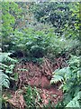
Site of Robin Hood's Cave near Annesley
Romantically associated with the famous outlaw who would sit here at the cave entrance surveying the wealthy travellers passing through the valley below carrying their valuable wares. A very helpful local chap who lives nearby explained how him and other local children would play in the cave before the unstable sandstone bedrock led to the local council infilling the site. There's nothing to see now really - the area is obscured by heavy bracken, gorse and sycamore undergrowth, some of which I had to scrape away to even obtain this picture. One for the imagination I guess...
Image: © Jonathan Clitheroe
Taken: 15 Jul 2022
0.19 miles
8
Annesley Woodhouse NG17, Notts.
This combined farm track, bridleway and public footpath - off Nuncargate Road - leads to Grives Farm and beyond it to the "Top Car Park" of Portland Park Nature Reserve, a "Site of Special Scientific Interest".
Image: © David Hallam-Jones
Taken: 28 Feb 2013
0.19 miles
9
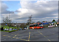
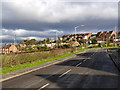
Derby Road, Annesley
Looking NNE up Derby Road. This long straight stretch of the A611 as it passes through Annesley is subject to a 30 mph speed limit. To enforce this, averaging speed cameras have been placed at intervals. One set of these can be seen on the left of this picture.
Image: © David P Howard
Taken: 18 Jun 2012
0.20 miles
10
Not Notts highest point
Whilst waiting at the traffic lights, I glanced across Derby Road at this house because the plaque caught my eye. It reads "AD 1904 Highest Point in Notts 609 feet above sea level". Having come down this road and had to apply quite a lot of braking to stop, I pondered the sign for a whole minute before the penny dropped - there was something wrong! Luckily, a fellow Geographer had been here before - Image Fortunately, I'm going to stop worrying about this inconsistency, because in about a year's time, the growth will have covered the plaque and all will be well again.
Image: © Trevor Rickard
Taken: 10 Sep 2009
0.21 miles