IMAGES TAKEN NEAR TO
High Crescent, NOTTINGHAM, NG17 9BT
Introduction
This page details the photographs taken nearby to High Crescent, NG17 9BT by members of the Geograph project.
The Geograph project started in 2005 with the aim of publishing, organising and preserving representative images for every square kilometre of Great Britain, Ireland and the Isle of Man.

There are currently over 7.5m images from over14,400 individuals and you can help contribute to the project by visiting https://www.geograph.org.uk
Image Map
Images are licensed for reuse under creativecommons.org/licenses/by-sa/2.0
Notes
- Clicking on the map will re-center to the selected point.
- The higher the marker number, the further away the image location is from the centre of the postcode.
Image Listing (23 Images Found)
Images are licensed for reuse under creativecommons.org/licenses/by-sa/2.0
Image
Details
Distance
1
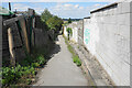
Footpath at Nuncargate
The path passes behind the back of houses on each side, and certainly existed before the houses to the right were built.
Image: © Bill Boaden
Taken: 3 Aug 2022
0.06 miles
2
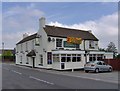
General Havelock Public House, Annesley Woodhouse
Major General Sir Henry Havelock, a Victorian Military War hero was actually born in Sunderland !
Image: © Phil Evans
Taken: 24 Jul 2008
0.16 miles
3
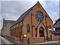
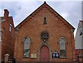
Wesleyan Church, Annesley Woodhouse
This is the current Wesleyan Church in Annesley Woodhouse. Just down the road from the old church http://www.geograph.org.uk/photo/895146.
Image: © Phil Evans
Taken: 24 Jul 2008
0.18 miles
4
The Badger Box, Annesley
A Hungry Horse pub
Image: © Chris Morgan
Taken: 3 May 2016
0.19 miles
5
Wesleyan Church, Annesley Woodhouse
The former Wesleyan Church; see pic of current Wesleyan Church http://www.geograph.org.uk/photo/895149.
Image: © Phil Evans
Taken: 24 Jul 2008
0.19 miles
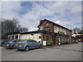
7
Badger Box
A modern Hungry Horse pub with Greene King beers.
Image: © Bill Boaden
Taken: 2 Jul 2022
0.20 miles
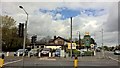
8
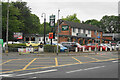
Derby Road, Annesley
Looking NNE up Derby Road. This long straight stretch of the A611 as it passes through Annesley is subject to a 30 mph speed limit. To enforce this, averaging speed cameras have been placed at intervals. One set of these can be seen on the left of this picture.
Image: © David P Howard
Taken: 18 Jun 2012
0.20 miles
9
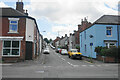
Fishers Street
One of several parallel roads off Nuncargate Road.
Image: © Bill Boaden
Taken: 3 Aug 2022
0.21 miles
10
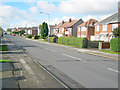
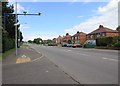
Forest Road
Long straight road heading west off Derby Road. Some 1930s style semi-detached houses here.
Image: © Trevor Rickard
Taken: 16 Oct 2010
0.21 miles