IMAGES TAKEN NEAR TO
Franklin Way, NOTTINGHAM, NG17 8SQ
Introduction
This page details the photographs taken nearby to Franklin Way, NG17 8SQ by members of the Geograph project.
The Geograph project started in 2005 with the aim of publishing, organising and preserving representative images for every square kilometre of Great Britain, Ireland and the Isle of Man.

There are currently over 7.5m images from over14,400 individuals and you can help contribute to the project by visiting https://www.geograph.org.uk
Image Map
Images are licensed for reuse under creativecommons.org/licenses/by-sa/2.0
Notes
- Clicking on the map will re-center to the selected point.
- The higher the marker number, the further away the image location is from the centre of the postcode.
Image Listing (11 Images Found)
Images are licensed for reuse under creativecommons.org/licenses/by-sa/2.0
Image
Details
Distance
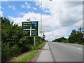
1
Footpath crossing of A38
Path leads to the primary school to the left
Image: © John Firth
Taken: 9 Jun 2013
0.10 miles
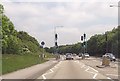
2
A38 Kings Mill Road East, Sutton in Ashfield (1)
Police investigating, after a road traffic accident.
Image: © John Topping
Taken: 25 Jun 2013
0.10 miles
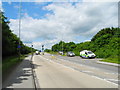
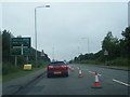
3
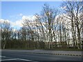
A38 Kings Mill Road East, Sutton in Ashfield (2)
Approaching the A38/B6018 junction from the east.
Image: © John Topping
Taken: 25 Jun 2013
0.18 miles
6
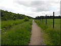
Path east side of Ashfield Rugby Ground
Path leading to Linorick Road from Penny Emma Way.
Image: © John Topping
Taken: 25 Jun 2013
0.22 miles
8

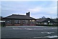
Kirkby In Ashfield fire station
Kirkby In Ashfield fire station, Sutton Road, Kirkby In Ashfield, Nottinghamshire
Image: © Kevin Hale
Taken: 4 Aug 2010
0.23 miles
9

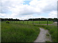
Footpath to the top of a reclaimed slag heap
Once part of Kirkby Colliery, which closed in 1968, now public open space.
Image: © Graham Hogg
Taken: 3 May 2016
0.24 miles
10
Ashfield Fire Station
Located on Sutton Road.
Image: © Jonathan Clitheroe
Taken: 5 Jan 2019
0.24 miles