IMAGES TAKEN NEAR TO
Princess Street, NOTTINGHAM, NG17 8LS
Introduction
This page details the photographs taken nearby to Princess Street, NG17 8LS by members of the Geograph project.
The Geograph project started in 2005 with the aim of publishing, organising and preserving representative images for every square kilometre of Great Britain, Ireland and the Isle of Man.

There are currently over 7.5m images from over14,400 individuals and you can help contribute to the project by visiting https://www.geograph.org.uk
Image Map
Images are licensed for reuse under creativecommons.org/licenses/by-sa/2.0
Notes
- Clicking on the map will re-center to the selected point.
- The higher the marker number, the further away the image location is from the centre of the postcode.
Image Listing (37 Images Found)
Images are licensed for reuse under creativecommons.org/licenses/by-sa/2.0
Image
Details
Distance
1
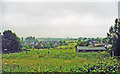
Site of former Kirkby Bentinck station, 2000
View westward from the B6018 road at Castle Hill near Kirkby-in-Ashfield, towards Chesterfield and Sheffield along the course of the ex-GCR Sheffield - Nottingham - London etc. main line! The station and this section of the line had been closed from 4/3/63 and the area has been totally transformed since the 1980s' closure of the numerous collieries and associated railways: in the past there had been five railway stations in this immediate area. (This station had been 'Kirkby & Pinxton' until 1/3/25).
Image: © Ben Brooksbank
Taken: 3 Jul 2000
0.00 miles
2
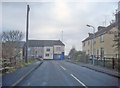
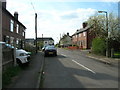
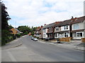
Bentinck Town
Looking west along Laburnum Avenue to the junction with Pinxton Road. Bentinck Town was named after the Duke of Portland (family name Cavendish-Bentinck), who owned the land and mines in this area and whose family were prominent British politicians. The name is originally Dutch. Hans William, Baron Bentinck, (later 1st Earl of Portland) was originally sent to England in 1677 to solicit for William of Orange the hand of Mary, daughter of the Duke of York (later James II). He was instrumental in the Dutch invasion and the reign of William and Mary.
http://en.wikipedia.org/wiki/William_Bentinck,_1st_Earl_of_Portland
Image: © Trevor Rickard
Taken: 28 Nov 2009
0.03 miles
3
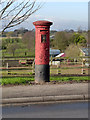
Church Hill postbox (Kirkby-in-Ashfield) ref NG17 411
Standard EVIIR pillar box, missing all its collection information and in dire need of a repaint. By no means the only scruffy postbox in the area.
Image: © Alan Murray-Rust
Taken: 5 Dec 2014
0.04 miles
4
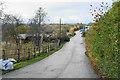
St Wilfrid's Park
I think the route only has this name because of houses which have been built to the right which require this road as access. It follows the line of a former railway.
Image: © Bill Boaden
Taken: 26 Nov 2021
0.05 miles
5
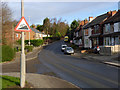
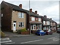
Church Hill, Kirkby-in-Ashfield
Looking up towards the old village of Kirkby.
Image: © Alan Murray-Rust
Taken: 5 Dec 2014
0.06 miles
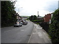
7
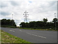
B6019 Pinxton Road/B6018 Park Lane junction, Bentinck town
Viewed from Pinxton Road.
Image: © John Topping
Taken: 25 Jun 2013
0.07 miles