IMAGES TAKEN NEAR TO
Halfmoon Drive, NOTTINGHAM, NG17 7FY
Introduction
This page details the photographs taken nearby to Halfmoon Drive, NG17 7FY by members of the Geograph project.
The Geograph project started in 2005 with the aim of publishing, organising and preserving representative images for every square kilometre of Great Britain, Ireland and the Isle of Man.

There are currently over 7.5m images from over14,400 individuals and you can help contribute to the project by visiting https://www.geograph.org.uk
Image Map
Images are licensed for reuse under creativecommons.org/licenses/by-sa/2.0
Notes
- Clicking on the map will re-center to the selected point.
- The higher the marker number, the further away the image location is from the centre of the postcode.
Image Listing (8 Images Found)
Images are licensed for reuse under creativecommons.org/licenses/by-sa/2.0
Image
Details
Distance
1
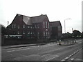
Kingsway Primary School
in Kirkby in Ashfield
Image: © Tom Courtney
Taken: 9 Oct 2005
0.20 miles
2
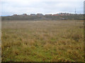
Waste ground near Portland Park - 2
Looking east to the railway embankment and the bridge over Lindley's Lane. Beyond the embankment are the houses on Grives Lane at the southern end of Kirkby-in-Ashfield.
Image: © Trevor Rickard
Taken: 28 Nov 2009
0.20 miles
3
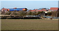
Portland Park Nature Reserve Area NG17, Notts.
A "Robin Hood Line" train heading towards Newstead, in the vicinity of the "Top Car Park" a free car park that serves the Portland Park Nature Reserve. A pedestrian has left the "Top Car Park" vicinity and is walking along Lindley's Lane. Lindley's Lane continues on the other side of the bridge in the direction of Kirkby-in-Ashfield. The 'new' houses on the other side of the railway line are situated on Sylvan Avenue.
Image: © David Hallam-Jones
Taken: 28 Feb 2013
0.20 miles
4

Kingsway New Cemetery, Kirkby in Ashfield
Opened in 1933.
Image: © Jonathan Thacker
Taken: 29 Dec 2019
0.21 miles
5
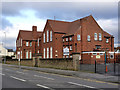
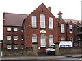
Kingsway Primary School
Typical large early 20th century urban school.
The symmetrical design highlights the then usual practice of segrtegating boys and girls.
Image: © Alan Murray-Rust
Taken: 30 Nov 2014
0.22 miles
6
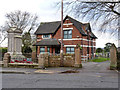
Kirkby in Ashfield Cemetery lodge and war memorial
This section of the cemetery is no longer in active use, the lodge now being used by small businesses. It dates from around 1880. The war memorial is Listed Grade II.
Image: © Alan Murray-Rust
Taken: 30 Nov 2014
0.22 miles
7
Kirkby-in-Ashfield - Kingsway Primary School
Image: © Dave Bevis
Taken: 28 Oct 2010
0.23 miles
8

Portland Park Nature Reserve Area NG17, Notts.
Lindley's Lane and the Portland Park Nature Reserve lie behind the photographer. This is Grives Lane, a through-road in the past between the B6021 (Kingsway-Nottingham Road) and Lindley's Lane but now only accessible by agricultural vehicles, walkers and cyclists. A railway embankment lies to the left and the level crossing ahead gives trains on the "Robin Hood Line" (the Mansfield-Nottingham service) the right of way.
Image: © David Hallam-Jones
Taken: 28 Feb 2013
0.25 miles