IMAGES TAKEN NEAR TO
Forest Street, NOTTINGHAM, NG17 7DU
Introduction
This page details the photographs taken nearby to Forest Street, NG17 7DU by members of the Geograph project.
The Geograph project started in 2005 with the aim of publishing, organising and preserving representative images for every square kilometre of Great Britain, Ireland and the Isle of Man.

There are currently over 7.5m images from over14,400 individuals and you can help contribute to the project by visiting https://www.geograph.org.uk
Image Map
Images are licensed for reuse under creativecommons.org/licenses/by-sa/2.0
Notes
- Clicking on the map will re-center to the selected point.
- The higher the marker number, the further away the image location is from the centre of the postcode.
Image Listing (24 Images Found)
Images are licensed for reuse under creativecommons.org/licenses/by-sa/2.0
Image
Details
Distance
1

Balfour Street, Kirkby
Seen from Diamond Avenue.
Image: © Richard Vince
Taken: 2 Dec 2017
0.09 miles
2
Back lane behind Clumber Street, Kirkby
Off Diamond Avenue. A set of allotments is behind the fence on the right.
Image: © Richard Vince
Taken: 2 Dec 2017
0.10 miles
4
Diamond, Avenue (B6020), Kirkby in Ashfield
Heading west.
Image: © JThomas
Taken: 18 Apr 2014
0.12 miles
5
Diamond Avenue, Kirkby
Looking towards the A611 from the edge of the town centre.
Image: © Richard Vince
Taken: 2 Dec 2017
0.13 miles
6
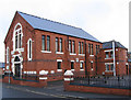
Kirkby-in-Ashfield - Baptist Church
On Forest Street.
Image: © Dave Bevis
Taken: 19 Oct 2010
0.14 miles
8
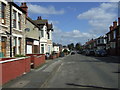
Clumber Street, Kirkby in Ashfield
Looking north.
Image: © JThomas
Taken: 18 Apr 2014
0.17 miles
9
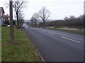
Diamond Avenue, Kirkby in Ashfield
The photograph doesn't really capture what is usually a sweeping view taking in the eastern edge of the Peak District, and Strawberry Bank, which is a previous claimant to the highest point in Notts (before exact measurements and mining spoil-heaps got in the way). At the foot of the hill is the crossroads with Kingsway, Station Street and the now-pedestrianised Lowmoor Road (Image) which forms the current centre of Kirkby.
Image: © Katy Walters
Taken: 25 Dec 2005
0.17 miles
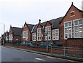
10
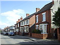
Houses on Clumber Street, Kirkby in Ashfield
Image: © JThomas
Taken: 18 Apr 2014
0.17 miles