IMAGES TAKEN NEAR TO
Hodgkinson Road, NOTTINGHAM, NG17 7DJ
Introduction
This page details the photographs taken nearby to Hodgkinson Road, NG17 7DJ by members of the Geograph project.
The Geograph project started in 2005 with the aim of publishing, organising and preserving representative images for every square kilometre of Great Britain, Ireland and the Isle of Man.

There are currently over 7.5m images from over14,400 individuals and you can help contribute to the project by visiting https://www.geograph.org.uk
Image Map
Images are licensed for reuse under creativecommons.org/licenses/by-sa/2.0
Notes
- Clicking on the map will re-center to the selected point.
- The higher the marker number, the further away the image location is from the centre of the postcode.
Image Listing (31 Images Found)
Images are licensed for reuse under creativecommons.org/licenses/by-sa/2.0
Image
Details
Distance
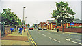
1
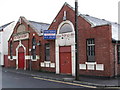
Kirkby-in-Ashfield - Salvation Army
On Morley Street.
Image: © Dave Bevis
Taken: 19 Oct 2010
0.10 miles
2
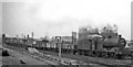
Down freight passing Kirkby-in-Ashfield East Station
View southward, towards Nottingham and Pye Bridge; ex-Midland Nottingham - Mansfield - Worksop line, junction of line from Pye Bridge. This station was closed on 6/9/65 and although the ex-Midland Nottingham - Mansfield - Worksop route was revived in the 1990s as the Robin Hood Line, through Kirkby this followed the alignment of the parallel ex-Great Northern (Leen Valley) line and the new Kirkby Station (opened on 17/11/96) was built on that alignment. The locomotive here heading a Down Class H freight is LMS 4F 0-6-0 No. 44531.
Image: © Ben Brooksbank
Taken: 13 Jul 1963
0.10 miles
3

Kingsley Street, Kirkby
Seen from Kingsway.
Image: © Richard Vince
Taken: 2 Dec 2017
0.12 miles
4
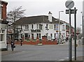
Kirkby-in-Ashfield - Nags Head
Photo taken from the northern end of Kingsway.
Image: © Dave Bevis
Taken: 18 Jan 2016
0.13 miles
6
Near site of Kirkby-in-Ashfield (LMS) station, 2000
View eastward on B6020 Urban Road/Station Street, Kirkby-in-Ashfield. Actually, this is just past where underneath ran the ex-Midland Nottingham - Mansfield - Worksop line, the station ('Kirkby-in-Ashfield East' from 15/6/59) being on the north side of this road. It had been a junction of a line from Pye Bridge and closed 6/9/65, when workmens' train from Pye Bridge ceased, the Nottingham - Worksop service having ceased 12/10/64. In more recent times it has been restored, on a different route (q.v.), as the Robin Hood Line.
Image: © Ben Brooksbank
Taken: 3 Jul 2000
0.14 miles
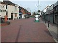
7

Low Moor Road, Kirkby in Ashfield
Pedestrianised shopping street in Kirkby with a 'Cashino' (slot machines) outlet on the immediate left.
Image: © Stephen McKay
Taken: 3 Sep 2016
0.14 miles
8
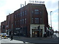
The Regent pub, Kirkby in Ashfield
Formerly a cinema and a bingo hall.
Image: © JThomas
Taken: 18 Apr 2014
0.14 miles
9
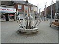
Shopping Area, Kirkby in Ashfield
this is Lowmoor Road looking north, seen from the junction with Diamond Avenue, Station Street and Kingsway. It is the central part of what is strictly East Kirkby, but is the main concentration of shops and services.
Image: © Tom Courtney
Taken: 9 Oct 2005
0.14 miles
10
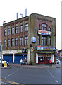
Kirkby-in-Ashfield - Regency Cinema
Closed in 2005. See http://cinematreasures.org/theater/24491/ for more details. Since this photo was taken, the building has been converted and re-opened as a Wetherspoon pub on 19 February 2013. A similar conversion was done in neighbouring Sutton-in-Ashfield in 2000 - please see Image
Image: © Dave Bevis
Taken: 18 Nov 2010
0.14 miles