IMAGES TAKEN NEAR TO
Searby Road, SUTTON-IN-ASHFIELD, NG17 5JQ
Introduction
This page details the photographs taken nearby to Searby Road, NG17 5JQ by members of the Geograph project.
The Geograph project started in 2005 with the aim of publishing, organising and preserving representative images for every square kilometre of Great Britain, Ireland and the Isle of Man.

There are currently over 7.5m images from over14,400 individuals and you can help contribute to the project by visiting https://www.geograph.org.uk
Image Map
Images are licensed for reuse under creativecommons.org/licenses/by-sa/2.0
Notes
- Clicking on the map will re-center to the selected point.
- The higher the marker number, the further away the image location is from the centre of the postcode.
Image Listing (8 Images Found)
Images are licensed for reuse under creativecommons.org/licenses/by-sa/2.0
Image
Details
Distance
3
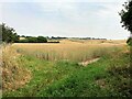
Crop Fields near Sutton-In-Ashfield
Path and farmland to the south east of the town. The footpath skirts this wheat field's right periphery.
Image: © Jonathan Clitheroe
Taken: 20 Jul 2022
0.22 miles
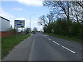
5

South end of Farndon Road, Sutton Junction
Image: © Richard Vince
Taken: 5 May 2018
0.24 miles
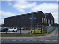
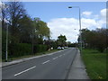
6

Newark Road, Sutton in Ashfield
A stretch of the B6022 leading out of Sutton. On the left LMG (Lion Motor Group) is a used car dealer.
Image: © Stephen McKay
Taken: 23 Jul 2016
0.24 miles
7
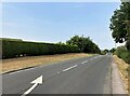
B6139 Coxmoor Road
Looking north west from a narrow roadside path.
Image: © Jonathan Clitheroe
Taken: 20 Jul 2022
0.24 miles