IMAGES TAKEN NEAR TO
Searby Road, SUTTON-IN-ASHFIELD, NG17 5HY
Introduction
This page details the photographs taken nearby to Searby Road, NG17 5HY by members of the Geograph project.
The Geograph project started in 2005 with the aim of publishing, organising and preserving representative images for every square kilometre of Great Britain, Ireland and the Isle of Man.

There are currently over 7.5m images from over14,400 individuals and you can help contribute to the project by visiting https://www.geograph.org.uk
Image Map
Images are licensed for reuse under creativecommons.org/licenses/by-sa/2.0
Notes
- Clicking on the map will re-center to the selected point.
- The higher the marker number, the further away the image location is from the centre of the postcode.
Image Listing (15 Images Found)
Images are licensed for reuse under creativecommons.org/licenses/by-sa/2.0
Image
Details
Distance
1

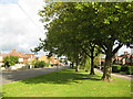
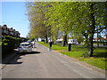
South end of Farndon Road, Sutton Junction
Image: © Richard Vince
Taken: 5 May 2018
0.05 miles
2
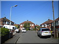
West end of Weston Close, Sutton Junction
Image: © Richard Vince
Taken: 5 May 2018
0.10 miles
3
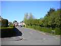
Leabrooks Avenue, Sutton Junction
Seen from Farndon Road.
Image: © Richard Vince
Taken: 5 May 2018
0.11 miles
4
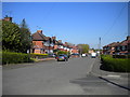
Northern half of Farndon Road, Sutton Junction
Seen from the junction with Sotheby Avenue.
Image: © Richard Vince
Taken: 5 May 2018
0.12 miles
6
Farndon Road, Sutton in Ashfield, Notts.
Image: © nick macneill
Taken: 21 Jul 2009
0.14 miles
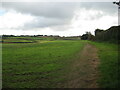
8
Crop Fields near Sutton-In-Ashfield
Path and farmland to the south east of the town. The footpath skirts this wheat field's right periphery.
Image: © Jonathan Clitheroe
Taken: 20 Jul 2022
0.18 miles
9
Service road alongside Kirkby Folly Road, Sutton Junction
Looking towards Kirkby.
Image: © Richard Vince
Taken: 5 May 2018
0.23 miles