IMAGES TAKEN NEAR TO
Hawthorne Close, SUTTON-IN-ASHFIELD, NG17 3NQ
Introduction
This page details the photographs taken nearby to Hawthorne Close, NG17 3NQ by members of the Geograph project.
The Geograph project started in 2005 with the aim of publishing, organising and preserving representative images for every square kilometre of Great Britain, Ireland and the Isle of Man.

There are currently over 7.5m images from over14,400 individuals and you can help contribute to the project by visiting https://www.geograph.org.uk
Image Map
Images are licensed for reuse under creativecommons.org/licenses/by-sa/2.0
Notes
- Clicking on the map will re-center to the selected point.
- The higher the marker number, the further away the image location is from the centre of the postcode.
Image Listing (20 Images Found)
Images are licensed for reuse under creativecommons.org/licenses/by-sa/2.0
Image
Details
Distance
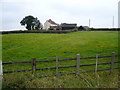
1
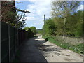
Track to Spring Wood Farm
Heading west from Stanton Hill.
Image: © JThomas
Taken: 18 Apr 2014
0.06 miles
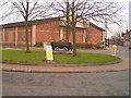
2
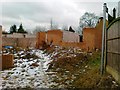
House under construction, Stanton Hill
Image: © Alex McGregor
Taken: 13 Feb 2012
0.12 miles
3
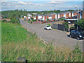
Meden Bank
Looking north with Silverhill in the distance. Modern houses on the western edge of Stanton Hill.
Image: © Trevor Rickard
Taken: 25 Sep 2010
0.16 miles
4
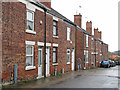
Stanton Hill - terraced housing on Cross Row
Road is called Cross Row on OS maps, but Cross Lane on AtoZ maps.
Image: © Dave Bevis
Taken: 7 Apr 2016
0.18 miles
5
Stanton Hill
On the roundabout is a redundant colliery tub from a local pit
Image: © John Poyser
Taken: 30 Nov 2006
0.18 miles
6
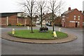
Stanton Hill roundabout
The coal truck planter in the middle of the roundabout is a reminder of the area's mining past.
Image: © Nikki Mahadevan
Taken: 30 Nov 2006
0.18 miles
7
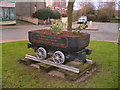
Tub on roundabout
The tub has details of the local pit closures painted on its sides
Image: © John Poyser
Taken: 30 Nov 2006
0.18 miles
8
Stubbinghill Farm
View from dismantled railway next to Brierley Forest Park.
Image: © Alan Heardman
Taken: 3 Oct 2007
0.19 miles
9
Fackley Road
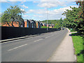
The B6014 heads north-west out of Stanton Hill. The housing estate on the left is fenced off from the main road and is accessed from the other side.
Image: © Trevor Rickard
Taken: 25 Sep 2010
0.20 miles
10
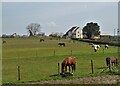
A view of Stubbinghill Farm
Clearly specialising in the accommodation of horses.
Image: © Neil Theasby
Taken: 20 Apr 2021
0.21 miles