IMAGES TAKEN NEAR TO
Silverhill Lane, SUTTON-IN-ASHFIELD, NG17 3JL
Introduction
This page details the photographs taken nearby to Silverhill Lane, NG17 3JL by members of the Geograph project.
The Geograph project started in 2005 with the aim of publishing, organising and preserving representative images for every square kilometre of Great Britain, Ireland and the Isle of Man.

There are currently over 7.5m images from over14,400 individuals and you can help contribute to the project by visiting https://www.geograph.org.uk
Image Map
Images are licensed for reuse under creativecommons.org/licenses/by-sa/2.0
Notes
- Clicking on the map will re-center to the selected point.
- The higher the marker number, the further away the image location is from the centre of the postcode.
Image Listing (45 Images Found)
Images are licensed for reuse under creativecommons.org/licenses/by-sa/2.0
Image
Details
Distance
1
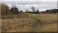
Silverhill Wood
This photograph was taken from the site of the Silverhill Colliery and is looking toward an area that was the route of a mineral railway line to the colliery from the Great Northern Railway. The line ran to the right of the hedge bounding the footpath and to the left of the corrugated building ahead.
The Ordnance Survey map of the area describes the houses on the right as ‘Silverhill Cottages.’
The Image on the left of the photograph leads, through reclaimed woodland, toward an area that was once occupied by a brick works associated with the Teversal Colliery.
Image: © Alan Walker
Taken: 16 Jan 2018
0.02 miles
2
Silverhill Wood Country Park
Meeting of tracks near entrance to the Country Park at Fackley
Image: © Alan Heardman
Taken: 13 Sep 2007
0.02 miles
3
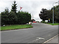
Teversal Campsite
This is the entrance to Teversal Campsite, an award-winning site owned by the Camping and Caravanning Club and run on a franchise basis (one of only a few Club sites run in this way). The picture was taken from the entrance to Silverhill Country Park.
Image: © Jonathan Kington
Taken: 22 Sep 2009
0.06 miles
4
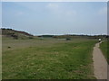
Silverhill Wood
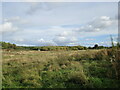
An area of reclaimed colliery land, this is mixed woodland, still quite young, open spaces, grassland and ponds.Silverhill Colliery opened in 1875 and closed in 1992.
Image: © Peter Barr
Taken: 25 Mar 2011
0.07 miles
5
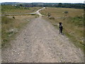
Footpath through woodland
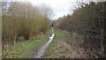
This footpath runs along the southern edge of Silverhill Wood and leads, through reclaimed woodland, toward an area that was once occupied by a brick works associated with the Teversal Colliery.
To the right, when the mines were still operating, there were the mineral line and sidings connecting to the Great Northern Railway branch line. To the left there were more sidings that were associated with a mineral line to the Teversal Colliery.
Ahead, this Image bears to the left before dividing into two alternate routes to the brick works.
Behind the viewpoint, the footpath begins in Image on the site of the Silverhill Colliery.
Image: © Alan Walker
Taken: 16 Jan 2018
0.07 miles
6
Ashfield : Silverhill Wood Country Park
Lots of paths to enjoy here.
Image: © Lewis Clarke
Taken: 2 Oct 2018
0.11 miles
7
Footpath through woodland
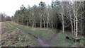
This footpath runs through reclaimed woodland toward an area that was once occupied by a brick works associated with the Teversal Colliery.
Behind the viewpoint this Image runs along side what was once the route of a mineral line and sidings connecting the Silverhill Colliery to the Great Northern Railway branch line.
The footpath into the trees on the right also leads toward the area of the brick works but via a decidedly muddier route!
Image: © Alan Walker
Taken: 16 Jan 2018
0.11 miles
8

Teversal Silverhill
Newly created path on reclaimed land at Silverhill mine
Image: © norman griffin
Taken: 28 Jan 2007
0.11 miles
9
The site of Silverhill Colliery
Now part of the Silverhill Wood Country Park.
Image: © Jonathan Thacker
Taken: 25 Oct 2021
0.12 miles
10
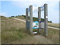
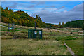
Silverhill Wood Country Park - Information Point
Image: © Alan Heardman
Taken: 13 Sep 2007
0.12 miles