IMAGES TAKEN NEAR TO
Fackley Road, SUTTON-IN-ASHFIELD, NG17 3HN
Introduction
This page details the photographs taken nearby to Fackley Road, NG17 3HN by members of the Geograph project.
The Geograph project started in 2005 with the aim of publishing, organising and preserving representative images for every square kilometre of Great Britain, Ireland and the Isle of Man.

There are currently over 7.5m images from over14,400 individuals and you can help contribute to the project by visiting https://www.geograph.org.uk
Image Map
Images are licensed for reuse under creativecommons.org/licenses/by-sa/2.0
Notes
- Clicking on the map will re-center to the selected point.
- The higher the marker number, the further away the image location is from the centre of the postcode.
Image Listing (42 Images Found)
Images are licensed for reuse under creativecommons.org/licenses/by-sa/2.0
Image
Details
Distance
1
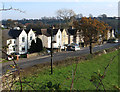
Teversal - Fackley Road
The houses on Fackley Road as seen from the Silverhill Trail.
Image: © Dave Bevis
Taken: 19 Nov 2011
0.10 miles
2
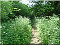
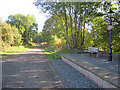
Teversal Trails
This footpath is one of many forming the Teversal Trails. The land was formerly railway track and Colliery land.
Image: © Sally Holmes
Taken: 18 Jun 2006
0.11 miles
3
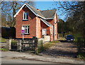
Fackley, near Teversal NG17, Notts.
"Station House" occupies this plot on the Stanton Hill side of a redundant railway bridge near The Carnarvon Arms pub, Fackley. The railway line and platform/s were accessed at the other end of the drive. Louis Zelickman, was the Station Master responsible for the station "Teversal Manor" for 17 years until the station closed in 1963, after which he continued to live in the house up until his death in 2008.
Image: © David Hallam-Jones
Taken: 2 Mar 2013
0.12 miles
4
Teversal Station
Looking north-east along the old line to Pleasley, which forms part of the Teversal Trails. The old station platform has been nicely restored and now provides a place to rest for walkers and cyclists.
Image: © Trevor Rickard
Taken: 25 Sep 2010
0.13 miles
5
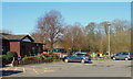
Fackley, Sutton-in-Ashfield NG17, Notts.
Beyond the picnic area to the right of the Teversal Visitors' Centre a path connects the car parking area with "The Link Trail" where cyclists and walkers can leave or access either "The Skegby Trail" or "The Teversal Trail". Various other local amenities are situated on the right of this spot including Fackley Cricket Club's ground and a children's playground area. Carnarvon Street, behind the photographer, provides a link with Fackley Road (the B6014) that links Stanton Hill, Nottinghamshire and Tibshelf, Derbyshire.
Image: © David Hallam-Jones
Taken: 2 Mar 2013
0.14 miles
6
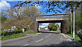
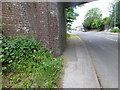
Teversal - former railway bridge over Fackley Road
The bridge used to carry the Midland Railway branch line from Alfreton to Mansfield via Pleasley. It now carries the multi-user Silverhill Trail.
Image: © Dave Bevis
Taken: 23 Apr 2016
0.14 miles
7
Teversal - Silverhill Trail to NE of Fackley Road bridge
This is the site of the Midland Railway station. Teversal also had a station of the Great Northern Railway and this was located to the north of the Midland station.
Image: © Dave Bevis
Taken: 23 Apr 2016
0.14 miles
8
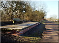
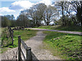
Teversal Manor Station, Fackley NG17, Notts.
Teversal Manor Station functioned between 1866-1963 when it finally ceased to function - for passengers at least - as a result of the Beeching British Railways rationalisation programme. The line linked with Pleasley. This (replica ?) platform on what is now a cycling and rambling trail is approximately 5 minutes walk from The Carnarvon Arms pub in Fackley - alongside the B6014 road - and it can be accessed ahead through the gate and footpath on the right. The bench commemorates the service of Louis Zelickman, the final Station Master, who worked here between 1946-64. When station closed, and following his retirement, he continued to live at the nearby Station Master's House until his death in 2008.
Image: © David Hallam-Jones
Taken: 2 Mar 2013
0.14 miles
9
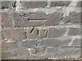
Cut Mark Disused Railway Bridge B6028 Fackley
Image: © Monica Stagg
Taken: 24 May 2015
0.14 miles