IMAGES TAKEN NEAR TO
Cochrane Terrace, SUTTON-IN-ASHFIELD, NG17 3GN
Introduction
This page details the photographs taken nearby to Cochrane Terrace, NG17 3GN by members of the Geograph project.
The Geograph project started in 2005 with the aim of publishing, organising and preserving representative images for every square kilometre of Great Britain, Ireland and the Isle of Man.

There are currently over 7.5m images from over14,400 individuals and you can help contribute to the project by visiting https://www.geograph.org.uk
Image Map
Images are licensed for reuse under creativecommons.org/licenses/by-sa/2.0
Notes
- Clicking on the map will re-center to the selected point.
- The higher the marker number, the further away the image location is from the centre of the postcode.
Image Listing (28 Images Found)
Images are licensed for reuse under creativecommons.org/licenses/by-sa/2.0
Image
Details
Distance
1
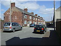
Cardiner Terrace, Stanton Hill
Off Stoneyford Road.
Image: © JThomas
Taken: 18 Apr 2014
0.02 miles
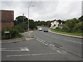
2
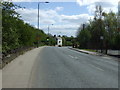
Stoneyford Road (B6028)
Heading south east towards Sutton-in-Ashfield.
Image: © JThomas
Taken: 18 Apr 2014
0.05 miles
4
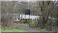
Exit to Stoneyford Road
The photograph shows the exit from Brierley Forest Park onto Image The road runs between Stanton Hill, to the left and Sutton-in-Ashfield, to the right.
It was near this point that the Midland Railway's Skegby Colliery Branch terminated, as can be seen from this OS map dated 1892-14 from the National Library of Scotland https://maps.nls.uk/geo/explore/side-by-side/#zoom=17&lat=53.1390&lon=-1.2720&layers=168&right=osm .
Image: © Alan Walker
Taken: 11 Mar 2018
0.06 miles
5
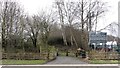
Entrance to Brierley Forest Park
The photograph shows the entrance into Brierley Forest Park from Image The road runs between Stanton Hill, to the right and Sutton-in-Ashfield, to the left.
It was near this point that the Midland Railway's Skegby Colliery Branch terminated as can be seen from this OS map dated 1892-14 from the National Library of Scotland https://maps.nls.uk/geo/explore/side-by-side/#zoom=17&lat=53.1390&lon=-1.2720&layers=168&right=osm .
Behind the viewpoint Image lead to Stanton Hill and Skegby.
Image: © Alan Walker
Taken: 11 Mar 2018
0.07 miles
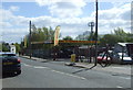
6
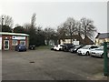
Parking Area and Canine Centre at Brierley Industrial Park
The building on the left is Sherwood Canine Hydrotherapy which in addition to rehabilitation also offers 'fun' swims for pets in a heated pool.
Image: © Jonathan Clitheroe
Taken: 11 Feb 2020
0.08 miles
7
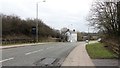
Stoneyford Road (B6028)
This south-easterly facing photograph is of Stoneyford Road. The road runs between Stanton Hill, behind the viewpoint and Sutton-in-Ashfield, ahead.
The viewpoint is adjacent to a public footpath, right foreground, leading into Brierley Forest Park.
It was near this point that the Midland Railway's Skegby Colliery Branch terminated, as can be seen from this OS map dated 1892-14 from the National Library of Scotland https://maps.nls.uk/geo/explore/side-by-side/#zoom=17&lat=53.1390&lon=-1.2720&layers=168&right=osm .
***
See also this photograph by JThomas:- Image
Image: © Alan Walker
Taken: 11 Mar 2018
0.10 miles
8
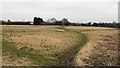
A number of paths
The photograph shows a number of paths that appear on the OS map which, although they are well used, are not recorded as public rights of way. The footpaths lead variously to Stanton Hill and Skegby across land that on some versions of the OS map is marked as a sports field, although such use seems to be a thing of the past.
Behind the viewpoint is some scrub land beyond which is Image and an Image The scrub land on some versions of the OS map is marked as allotment gardens and again such use seems to be a thing of the past.
Image: © Alan Walker
Taken: 11 Mar 2018
0.10 miles
9
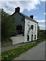
View from Fisher Close towards The Miners Arms
Image: © Alan Heardman
Taken: 20 Sep 2012
0.10 miles