IMAGES TAKEN NEAR TO
Buttery Lane, SUTTON-IN-ASHFIELD, NG17 3DZ
Introduction
This page details the photographs taken nearby to Buttery Lane, NG17 3DZ by members of the Geograph project.
The Geograph project started in 2005 with the aim of publishing, organising and preserving representative images for every square kilometre of Great Britain, Ireland and the Isle of Man.

There are currently over 7.5m images from over14,400 individuals and you can help contribute to the project by visiting https://www.geograph.org.uk
Image Map
Images are licensed for reuse under creativecommons.org/licenses/by-sa/2.0
Notes
- Clicking on the map will re-center to the selected point.
- The higher the marker number, the further away the image location is from the centre of the postcode.
Image Listing (47 Images Found)
Images are licensed for reuse under creativecommons.org/licenses/by-sa/2.0
Image
Details
Distance
1
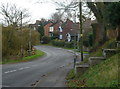
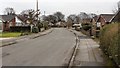
Buttery Lane, Skegby
The lane marks the edge of Skegby, with houses lining one side only.
Image: © Andrew Hill
Taken: 1 Dec 2011
0.04 miles
2
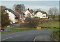
Houses, field and road, Skegby
A suburban scene at Skegby near the edge of the built up areas surrounding Mansfield.
Image: © Andrew Hill
Taken: 1 Dec 2011
0.09 miles
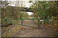
4
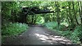
Bridge over the Skegby Trail
This southward facing photograph shows a bridge over the Skegby Trail. The bridge would appear to have had only one purpose, to connect one side of a farm to the other, the farm having been split in two by the Great Northern Railway’s line to Pleasley.
An OS map dated 1900 shows a double track line to Skegby on the left with sidings on the right. This arrangement was still in place as shown on another OS map dated c.1948.
For a photograph of the Skegby Trail taken some 350m ahead at a point close to where the Skegby railway station once stood and where it shares a footpath with Buttery Lane, click here Image
Behind the viewpoint is the site of Skegby Junction (See this photograph:- Image) where a branch line to the Silverhill and Teversal Collieries joined this line.
See also this photograph by Nikki Mahadevan, Image
Image: © Alan Walker
Taken: 25 May 2017
0.14 miles
5
Greenland Road
The photograph shows the southern end of the cul-de-sac Greenland Road. Ahead, a public footpath leads out of the cul-de-sac to High Tor with a branch off toward the churchyard of St Andrew's Church.
Image: © Alan Walker
Taken: 18 Feb 2018
0.14 miles
6
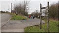
Skegby Trail
The photograph shows the entrance off Buttery Lane, Skegby into a car park for the Skegby Trail.
When this trail was created it was called the 'Skegby Track' rather than the 'Skegby Trail' which, presumably, was a reference to these routes originally being railway tracks.
Similar signage can be seen in this photograph at Image and in this photograph by Alan Murray-Rust of the Image The change from 'track' to 'trail' appears to have been made before Image was constructed.
Originally there was another board above 'Skegby Track' where the wording 'Teversal Trails' was included. This was a collective reference to the group of three trails, namely the Skegby Trail, the Link Trail and the Teversal Trail. These trails are included in the Ashfield Trails Network http://www.nottinghamshire.gov.uk/planning-and-environment/countryside-and-green-spaces/green-spaces/teversal-trails and the Phoenix Greenways network https://derbyshire.gov.uk/images/Phoenix%20Greenways%202015%20web_tcm44-159660.pdf .'
For a photograph of the Skegby Trail taken some 350m ahead, click here:- Image
Behind the viewpoint there is Image
Image: © Alan Walker
Taken: 18 Feb 2018
0.14 miles
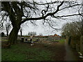
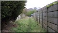
7
Teversal Trail, Skegby
A bridge crosses the Skegby arm of the Teversal Trail.
Image: © Nikki Mahadevan
Taken: 30 Nov 2006
0.14 miles
8
Public footpath
The photograph shows the southern end of a public footpath that runs southward from Teversal to Wheatfield Way (just ahead) in Skegby https://en.wikipedia.org/wiki/Skegby .
Some 75m behind the viewpoint the footpath crosses Image
Ahead Wheatfield Way is a cul-de-sac, which has a junction with Image
Image: © Alan Walker
Taken: 18 Feb 2018
0.14 miles
9
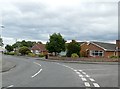
Bungalows on Manor Road
At its junction with Greenland Road.
Image: © Graham Hogg
Taken: 12 Jun 2017
0.16 miles
10
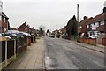
Elder Street
The photograph shows Elder Street in Skegby. At the viewpoint a public footpath from Teversal to Skegby https://en.wikipedia.org/wiki/Skegby crosses the street right to left.
For a photograph of the footpath taken some 75m to the south (left of the viewpoint), click here:- Image
For a photograph of the footpath taken some 125m to the north (right of the viewpoint) in a section that runs from Ash Grove to Elder Street, click here:- Image
See also this photograph by Andrew Hill :- Image
Image: © Alan Walker
Taken: 18 Feb 2018
0.18 miles