IMAGES TAKEN NEAR TO
St. Andrews Crescent, SUTTON-IN-ASHFIELD, NG17 3AU
Introduction
This page details the photographs taken nearby to St. Andrews Crescent, NG17 3AU by members of the Geograph project.
The Geograph project started in 2005 with the aim of publishing, organising and preserving representative images for every square kilometre of Great Britain, Ireland and the Isle of Man.

There are currently over 7.5m images from over14,400 individuals and you can help contribute to the project by visiting https://www.geograph.org.uk
Image Map
Images are licensed for reuse under creativecommons.org/licenses/by-sa/2.0
Notes
- Clicking on the map will re-center to the selected point.
- The higher the marker number, the further away the image location is from the centre of the postcode.
Image Listing (48 Images Found)
Images are licensed for reuse under creativecommons.org/licenses/by-sa/2.0
Image
Details
Distance
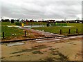
2
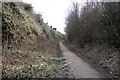
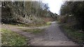
The Skegby Trail
This southerly facing photograph is of the Skegby Trail at a point where it rises through a fairly steep gradient in quite a deep cutting.
To see a photograph of the trail taken a short distance beyond the curve ahead and looking back in this direction, click here:- Image
To see another photograph of the trail taken a short distance behind the viewpoint, click here:- Image
- - -
The Skegby Trail was built on the track bed of the former Great Northern Railway's Leen Valley Extensions branch line running between Shirebrook and Kirkby-in-Ashfield. This line gave the company access to local collieries including those at Pleasley and Shirebrook.
Image: © Alan Walker
Taken: 7 Mar 2018
0.09 miles
3
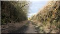
The Skegby Trail
This northerly facing photograph is of the Skegby Trail at a point where the old trackbed descends through a fairly steep gradient in quite a deep cutting.
To see a photograph of the trail taken a short distance beyond the curve ahead and looking back in this direction, click here:- Image
To see a photograph of the trail taken some 200m behind the viewpoint, click here:- Image
- - -
The Skegby Trail was built on the track bed of the former Great Northern Railway's Leen Valley Extensions branch line running between Shirebrook and Kirkby-in-Ashfield. This line gave the company access to local collieries including those at Pleasley and Shirebrook.
Image: © Alan Walker
Taken: 7 Mar 2018
0.09 miles
5
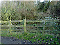
Site of footbridge across the railway
Despite having clearly been demolished some time ago, the bridge still appears on all scales of OS mapping. The resultant footpath diversions are however correctly mapped.
Image: © Alan Murray-Rust
Taken: 5 Dec 2014
0.11 miles
6
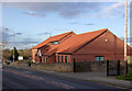
St Andrews C of E School
Built in 1865 on land donated by Lady Carnarvon. There are substantial extensions out of picture to the left.
Image: © Alan Murray-Rust
Taken: 5 Dec 2014
0.11 miles
7
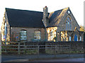
Skegby - St Andrews School
According to a metal plaque on the school perimeter wall, built in 1866 on land donated by Lady Carnarvon.
Image: © Dave Bevis
Taken: 1 Dec 2013
0.11 miles
8
The Skegby Trail
This southerly facing photograph is of the Skegby Trail at a point where it is crossed by a public footpath running from near Skegby Hall (to the right) to Saville Road (to the left).
For a photograph of the trail taken a short distance ahead. Click here Image
To see a northerly facing photograph of the trail taken a few metres behind the viewpoint, click here:- Image
- - -
The Skegby Trail was built on the track bed of the former Great Northern Railway's Leen Valley Extensions branch line running between Shirebrook and Kirkby-in-Ashfield. This line gave the company access to local collieries including those at Pleasley and Shirebrook.
Image: © Alan Walker
Taken: 7 Mar 2018
0.12 miles
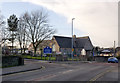
9
Skegby Methodist Church
The new church and social centre replaced the earlier 19th century chapel in 2005.
Image: © Alan Murray-Rust
Taken: 5 Dec 2014
0.14 miles