IMAGES TAKEN NEAR TO
Farmers Close, SUTTON-IN-ASHFIELD, NG17 2TG
Introduction
This page details the photographs taken nearby to Farmers Close, NG17 2TG by members of the Geograph project.
The Geograph project started in 2005 with the aim of publishing, organising and preserving representative images for every square kilometre of Great Britain, Ireland and the Isle of Man.

There are currently over 7.5m images from over14,400 individuals and you can help contribute to the project by visiting https://www.geograph.org.uk
Image Map
Images are licensed for reuse under creativecommons.org/licenses/by-sa/2.0
Notes
- Clicking on the map will re-center to the selected point.
- The higher the marker number, the further away the image location is from the centre of the postcode.
Image Listing (11 Images Found)
Images are licensed for reuse under creativecommons.org/licenses/by-sa/2.0
Image
Details
Distance
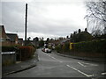
2
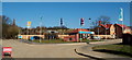
Huthwaite, Sutton-in-Ashfield NG17, Notts.
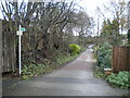
The start (or end) of Mill Lane, an unsurfaced track descending from the B6026 road can be seen here on the left. On its way uphill (or downhill) it passes between the rear entrances of Huthwaite cemetery and "The Welfare (recreation) Ground". A row of half a dozen or so terraced houses known as "Colliery Cottages", associated with the former New Hucknall Colliery that existed until 1982, are situated behind the photographer's left shoulder. The Mill House Gardens housing development on the left (although not visible here) was completed some time ago (? date) and now the "Brierley Hills" housing development can be seen evolving on the right. Brierley Hill, Staffordshire is where some of the first miners in Huthwaite came from during the early 1870s.
Image: © David Hallam-Jones
Taken: 2 Mar 2013
0.04 miles
3
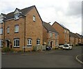
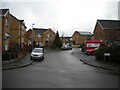
Windmill Way, Huthwaite
New housing in a development known as Brierley Hills.
Image: © Neil Theasby
Taken: 20 Apr 2021
0.07 miles
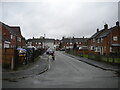
4
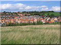
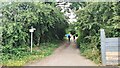
Housing north of Mill Lane
The photograph was taken from the footpath to the south of Mill Lane. The western boundary of an old colliery, which is currently being landfilled, can be seen to the right of the picture Image
Image: © Nikki Mahadevan
Taken: 19 Sep 2006
0.12 miles
5
East end of Cross Lane, Huthwaite
At this point, it becomes a restricted byway.
Image: © Richard Vince
Taken: 12 Dec 2020
0.15 miles
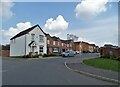
6
Mercia Court, Huthwaite
A residential cul de sac off Cross Lane.
Image: © Richard Vince
Taken: 12 Dec 2020
0.16 miles
8
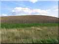
Landfill south of Huthwaite
The western perimeter of a landfill site on former coal workings.
Image: © Nikki Mahadevan
Taken: 19 Sep 2006
0.19 miles
9
East end of Greenwood Avenue, Huthwaite
Off Columbia Street.
Image: © Richard Vince
Taken: 12 Dec 2020
0.21 miles
10
South end of Greenwood Avenue, Huthwaite
Off Cross Lane.
Image: © Richard Vince
Taken: 12 Dec 2020
0.24 miles