IMAGES TAKEN NEAR TO
Parkside, SUTTON-IN-ASHFIELD, NG17 2PN
Introduction
This page details the photographs taken nearby to Parkside, NG17 2PN by members of the Geograph project.
The Geograph project started in 2005 with the aim of publishing, organising and preserving representative images for every square kilometre of Great Britain, Ireland and the Isle of Man.

There are currently over 7.5m images from over14,400 individuals and you can help contribute to the project by visiting https://www.geograph.org.uk
Image Map
Images are licensed for reuse under creativecommons.org/licenses/by-sa/2.0
Notes
- Clicking on the map will re-center to the selected point.
- The higher the marker number, the further away the image location is from the centre of the postcode.
Image Listing (68 Images Found)
Images are licensed for reuse under creativecommons.org/licenses/by-sa/2.0
Image
Details
Distance
1
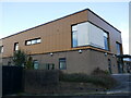
Brierley Park Medical Centre, Huthwaite
Image: © Jonathan Thacker
Taken: 16 Feb 2024
0.05 miles
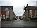
2
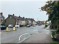
Sutton Road in Huthwaite
Looking east near its junction with Newcastle Street.
Image: © Jonathan Clitheroe
Taken: 5 Oct 2022
0.07 miles
3
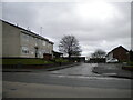
Mill Close, Huthwaite
Off Sutton Road.
Image: © Richard Vince
Taken: 12 Dec 2020
0.07 miles
4
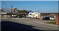
Huthwaite, Sutton-in-Ashfield NG17, Notts.
A plot of rough ground until recently, this brown-field corner site at the junction of Skegby Road with the B6026 (Sutton Road) is being used to host the new £2.6m, two-storey Huthwaite Medical Centre. When completed in "Spring 2013" it will replace the G.P. practice premises on nearby New Street and it will include an on-site retail pharmacy. A two-three minute walk down Skegby Road, past the parked cars, leads to The Brierley Forest Park visitors' centre on the edge of this large nature reserve. The colliery on which the reserve was developed was known locally as "Brierley Pit" because many of the first miners came from Brierley Hill in Staffordshire in the early 1870s.
Image: © David Hallam-Jones
Taken: 2 Mar 2013
0.07 miles
5
Newcastle Street, Huthwaite
Off Sutton Road.
Image: © Richard Vince
Taken: 12 Dec 2020
0.07 miles
6
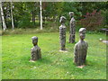
A Mining Family
Another view of figures near Brierley Forest Park Visitors Centre.
Image: © Alan Heardman
Taken: 3 Oct 2007
0.09 miles
7
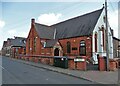
Greek Orthodox Church in Huthwaite
Dedicated to Saints Cyril and Methodius.
Image: © Neil Theasby
Taken: 20 Apr 2021
0.09 miles
8
Welfare Park, Huthwaite (2)
The entrance from Sutton Road, with a small car park leading to a footpath into the park proper.
Image: © Richard Vince
Taken: 12 Dec 2020
0.10 miles
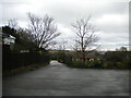
9
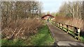
Path to the visitor centre
This northerly facing photograph shows one of the access paths to the Brierley Forest visitor centre, which can be seen ahead. Parking at the centre itself is reserved for staff and disabled visitors.
Immediately behind the viewpoint is one of the visitor car parking areas at the northern end of Skegby Road.
To the right of the viewpoint is a footpath that leads over what Image to Image
Some 150m to the left of the viewpoint, having passed through more car parking, is access to a Image within the park boundary.
See this photograph by Alan Heardman, which shows the same view before the fencing on the right was added:- Image
See also this photograph by Trevor Rickard:- Image
Image: © Alan Walker
Taken: 30 Jan 2018
0.10 miles
10
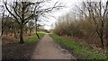
Footpath to the Brierley Forest Park main entrance
This photograph is facing in the direction of car parking at the northern end of Skegby Road. Some 120m ahead is the first of the car parking areas (to the left) and an access path to the visitor centre (to the right).
Further ahead still (some 280m) is a playing field within the park boundary.
Some 240m behind the viewpoint is what Image
Image: © Alan Walker
Taken: 30 Jan 2018
0.10 miles