IMAGES TAKEN NEAR TO
Mill Lane, SUTTON-IN-ASHFIELD, NG17 2NJ
Introduction
This page details the photographs taken nearby to Mill Lane, NG17 2NJ by members of the Geograph project.
The Geograph project started in 2005 with the aim of publishing, organising and preserving representative images for every square kilometre of Great Britain, Ireland and the Isle of Man.

There are currently over 7.5m images from over14,400 individuals and you can help contribute to the project by visiting https://www.geograph.org.uk
Image Map
Images are licensed for reuse under creativecommons.org/licenses/by-sa/2.0
Notes
- Clicking on the map will re-center to the selected point.
- The higher the marker number, the further away the image location is from the centre of the postcode.
Image Listing (59 Images Found)
Images are licensed for reuse under creativecommons.org/licenses/by-sa/2.0
Image
Details
Distance
1
Huthwaite, Sutton-in-Ashfield NG17, Notts.
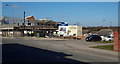
A plot of rough ground until recently, this brown-field corner site at the junction of Skegby Road with the B6026 (Sutton Road) is being used to host the new £2.6m, two-storey Huthwaite Medical Centre. When completed in "Spring 2013" it will replace the G.P. practice premises on nearby New Street and it will include an on-site retail pharmacy. A two-three minute walk down Skegby Road, past the parked cars, leads to The Brierley Forest Park visitors' centre on the edge of this large nature reserve. The colliery on which the reserve was developed was known locally as "Brierley Pit" because many of the first miners came from Brierley Hill in Staffordshire in the early 1870s.
Image: © David Hallam-Jones
Taken: 2 Mar 2013
0.02 miles
2
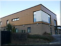
Brierley Park Medical Centre, Huthwaite
Image: © Jonathan Thacker
Taken: 16 Feb 2024
0.03 miles
3
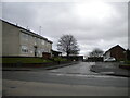
Mill Close, Huthwaite
Off Sutton Road.
Image: © Richard Vince
Taken: 12 Dec 2020
0.04 miles
4
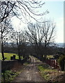
Huthwaite, Sutton-in-Ashfield, NG17, Notts.
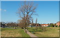
Mill Lane, a reverse L-shaped unsurfaced track, links Sutton Road (the B6026) and Common Road (B6027). On the left is a secondary entrance to Huthwaite Cemetery. The gates are open during its opening hours but only to pedestrians as vehicules are no longer permitted to use the track. Huthwaite Cemetery was formally opened in 1888 to cater for the burial of local people once the graveyard of the Church of St Mary Magdalene in Sutton was full. In 1912, and again in 1915, Huthwaite Urban District Council purchased additional land (seen here) on the site of a former farm, Mill House Farm. The farm house faced this lane and parts of this stone wall once served as one of the farm's boundary walls. Use of the word "mill" stems from the existence of a windmill on top of the hill that forms the main part of the cemetery.
Image: © David Hallam-Jones
Taken: 2 Mar 2013
0.05 miles
5
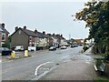
Sutton Road in Huthwaite
Looking east near its junction with Newcastle Street.
Image: © Jonathan Clitheroe
Taken: 5 Oct 2022
0.07 miles
6
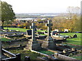
Huthwaite - cemetery
View towards The Common.
Image: © Dave Bevis
Taken: 30 Oct 2010
0.09 miles
7
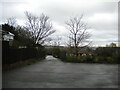
Welfare Park, Huthwaite (2)
The entrance from Sutton Road, with a small car park leading to a footpath into the park proper.
Image: © Richard Vince
Taken: 12 Dec 2020
0.09 miles
8
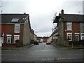
Newcastle Street, Huthwaite
Off Sutton Road.
Image: © Richard Vince
Taken: 12 Dec 2020
0.09 miles
9
Huthwaite - Welfare Park
Looking west towards Columbia Street. This park is maintained by Ashfield District Council (see http://www.ashfield-dc.gov.uk/residents/waste-and-environment/environment/parks-and-open-spaces/outdoor-sport.aspx ).
Image: © Dave Bevis
Taken: 2 Jul 2015
0.10 miles
10
Huthwaite, Sutton-in-Ashfield NG17, Notts
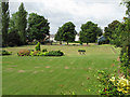
"The Huthwaite (miners') Welfare (recreation) Ground" is sandwiched between Columbia Street and Mill Lane, an unsurfaced track from where this picture was taken. Both of these plummet downhill from the main road that passes through Huthwaite i.e. the B6026. This land was donated for community use by the New Hucknall Colliery Company and the original access to it when it first opened in 1920 was via a set of gates off Columbia Street. The newer 'main entrance', off the B6026, was created later. A path, beneath this one, connected these two thoroughfares and was regularly walked by coal miners going to and from the New Hucknall Colliery.
a miners welfare sports ground, pavilion and recreation ground in Columbia Street, Sutton Road.
Image: © David Hallam-Jones
Taken: 2 Mar 2013
0.11 miles