IMAGES TAKEN NEAR TO
Barker Street, SUTTON-IN-ASHFIELD, NG17 2LH
Introduction
This page details the photographs taken nearby to Barker Street, NG17 2LH by members of the Geograph project.
The Geograph project started in 2005 with the aim of publishing, organising and preserving representative images for every square kilometre of Great Britain, Ireland and the Isle of Man.

There are currently over 7.5m images from over14,400 individuals and you can help contribute to the project by visiting https://www.geograph.org.uk
Image Map
Images are licensed for reuse under creativecommons.org/licenses/by-sa/2.0
Notes
- Clicking on the map will re-center to the selected point.
- The higher the marker number, the further away the image location is from the centre of the postcode.
Image Listing (29 Images Found)
Images are licensed for reuse under creativecommons.org/licenses/by-sa/2.0
Image
Details
Distance
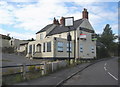
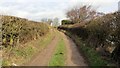
2
Right of way
This right of way crosses Image in Huthwaite.
Ahead the public right of way is a mixture of footpaths and tracks that lead to the Brierley Branch Line (Part of the Phoenix Greenways Trails:- https://www.derbyshire.gov.uk/images/Phoenix%20Greenways%202015%20web_tcm44-159660.pdf ). The path leads to other paths and tracks that take the walker to the Brierley Forest Park visitor centre or in a short loop to Image
Turning right, at the far end of Barker Street, another public right of way gives access to Wenham Lane to the left and Woodland View Primary School to the right.
The photograph was taken from Back Lane which, behind the viewpoint, leads to Wenham Lane.
Image: © Alan Walker
Taken: 30 Jan 2018
0.01 miles
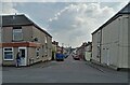
3
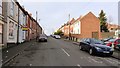
Barker Street
This north-westerly facing photograph is of Barker Street in Huthwaite. Just a few metres behind the viewpoint is Image
Ahead, at the house with the white wall-end a public Image crosses giving access to Back Lane.
At the far end of Barker Street another public Image gives access to Wenham Lane to the left and Woodland View Primary School to the right.
Image: © Alan Walker
Taken: 30 Jan 2018
0.01 miles
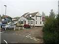
4

The junction of Main Street and Barker Street
The viewpoint of this photograph is at the northern of Main Street in Huthwaite. Ahead and to the left is the junction with Image, a cul-de-sac.
To the right is a Image that leads to an Image at the northern end of Newcastle Street.
Straight ahead a public right of way follows the track passed Brierley Forest Golf Club buildings and then onto a public footpaths which loop round into Barker Street, lead on into Brierley Forest Park visitor centre or link with the Brierley Branch Line.
The Brierley Branch Line ( https://www.derbyshire.gov.uk/images/Phoenix%20Greenways%202015%20web_tcm44-159660.pdf ) follows the old trackbed of the Midland Railway's Skegby branch line.
Image: © Alan Walker
Taken: 30 Jan 2018
0.07 miles
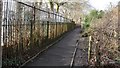
6
Right of way
The viewpoint of this right of way is adjacent to Woodland View Primary School, which is on the other other side of the hedge on the right.
Ahead the public right of way is a mixture of footpaths and tracks that lead across Herrod's Hill to the Brierley Branch Line (Part of the Phoenix Greenways Trails:- https://www.derbyshire.gov.uk/images/Phoenix%20Greenways%202015%20web_tcm44-159660.pdf ).
Behind the viewpoint the track crosses the end of Image before its junction with Wenham Lane.
Image: © Alan Walker
Taken: 30 Jan 2018
0.11 miles
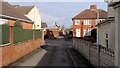
8
Public footpath
The photograph shows a public footpath that runs from an Image near the northern end of Newcastle Street (behind the viewpoint) to the junction of Main Street and Barker Street (ahead).
Image: © Alan Walker
Taken: 30 Jan 2018
0.13 miles
9
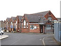
Huthwaite - John Davies Workshops
The current John Davies Primary School is about 300 metres north-west of its former site.
Image: © Dave Bevis
Taken: 15 Aug 2009
0.15 miles
10

Huthwaite - Methodist Church
This is the side chapel to the Methodist Church on Sherwood Street.
Image: © Dave Bevis
Taken: 10 Oct 2009
0.15 miles