IMAGES TAKEN NEAR TO
Dunelm Close, SUTTON-IN-ASHFIELD, NG17 2EX
Introduction
This page details the photographs taken nearby to Dunelm Close, NG17 2EX by members of the Geograph project.
The Geograph project started in 2005 with the aim of publishing, organising and preserving representative images for every square kilometre of Great Britain, Ireland and the Isle of Man.

There are currently over 7.5m images from over14,400 individuals and you can help contribute to the project by visiting https://www.geograph.org.uk
Image Map
Images are licensed for reuse under creativecommons.org/licenses/by-sa/2.0
Notes
- Clicking on the map will re-center to the selected point.
- The higher the marker number, the further away the image location is from the centre of the postcode.
Image Listing (7 Images Found)
Images are licensed for reuse under creativecommons.org/licenses/by-sa/2.0
Image
Details
Distance
1
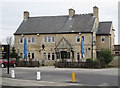
Sutton-in-Ashfield - The Travellers Rest
Pub on north side of Huthwaite Road.
Image: © Dave Bevis
Taken: 5 Mar 2015
0.14 miles
2

Sutton Cemetery
The north end of a very large cemetery with housing around Westbourne Road beyond.
Image: © Trevor Rickard
Taken: 12 Jun 2011
0.16 miles
3

Sutton-in-Ashfield - Ashfield College (west side)
Now part of West Notts College.
Image: © Dave Bevis
Taken: 2 Sep 2010
0.20 miles
4
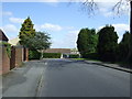
Springwood View Close
North of Huthwaite Road.
Image: © JThomas
Taken: 18 Apr 2014
0.22 miles
5
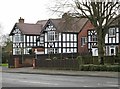
Sutton-in-Ashfield - half-timbered houses
These three houses (Nos 135/7/9) are part of a row of half-timbered houses on the south side of Huthwaite Road.
Image: © Dave Bevis
Taken: 5 Mar 2015
0.23 miles
6
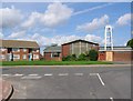
Community of Christ church, Carsic Estate
The Church is situated on the Carsic Estate, in an area known as the Oval. So called because the road in front of the church forms an oval around an area of housing, playing fields and shops.
Image: © Nikki Mahadevan
Taken: 19 Sep 2006
0.24 miles
7
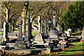
Sutton-in-Ashfield Cemetery
19th century grave monuments. There appear to be a concentration of these more elaborate ones in the central avenue.
Image: © Alan Murray-Rust
Taken: 5 Dec 2014
0.24 miles