IMAGES TAKEN NEAR TO
Davies Close, SUTTON-IN-ASHFIELD, NG17 2AZ
Introduction
This page details the photographs taken nearby to Davies Close, NG17 2AZ by members of the Geograph project.
The Geograph project started in 2005 with the aim of publishing, organising and preserving representative images for every square kilometre of Great Britain, Ireland and the Isle of Man.

There are currently over 7.5m images from over14,400 individuals and you can help contribute to the project by visiting https://www.geograph.org.uk
Image Map
Images are licensed for reuse under creativecommons.org/licenses/by-sa/2.0
Notes
- Clicking on the map will re-center to the selected point.
- The higher the marker number, the further away the image location is from the centre of the postcode.
Image Listing (17 Images Found)
Images are licensed for reuse under creativecommons.org/licenses/by-sa/2.0
Image
Details
Distance
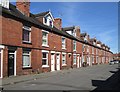
1

Sutton-in-Ashfield - terrace on west side of York Street (from NE)
Image: © Dave Bevis
Taken: 3 Jul 2015
0.13 miles
2
Sutton-in-Ashfield - terrace on west side of York Street (from SE)
Image: © Dave Bevis
Taken: 3 Jul 2015
0.13 miles
3
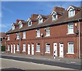
Sutton-in-Ashfield - terrace on north side of Priestsic Road (from SE)
Image: © Dave Bevis
Taken: 3 Jul 2015
0.16 miles
4

Sutton-in-Ashfield - terrace on north side of Priestsic Road (from SW)
Image: © Dave Bevis
Taken: 3 Jul 2015
0.16 miles
5
Davies Avenue, Sutton in Ashfield
Off Carsic Lane.
Image: © Richard Vince
Taken: 6 Apr 2019
0.16 miles
6
West end of Percival Crescent, Sutton in Ashfield
Seen from Carsic Lane.
Image: © Richard Vince
Taken: 6 Apr 2019
0.16 miles
7
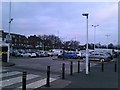
Supermarket Car Park in Sutton in Ashfield
Pictured on a late Saturday afternoon in early January. The houses on the left front onto the B6023 road.
Image: © Jonathan Clitheroe
Taken: 5 Jan 2019
0.17 miles
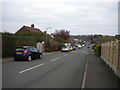
8

Cycle and pedestrian route
This path is part of Sutton-in-Asfield's sustainable cycle and pedestrian route to work scheme. The path follows the track bed of an old colliery railway to join the Teversal Trails north of Skegby.
Image: © Nikki Mahadevan
Taken: 19 Sep 2006
0.17 miles
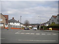
9
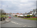
North end of Carsic Lane, Sutton in Ashfield
Looking towards Carsic Estate from the end of Jubilee Road.
Image: © Richard Vince
Taken: 6 Apr 2019
0.17 miles
10

The Old Blue Bell, Sutton-in-Ashfield
Mid to late 18th century public house, currently unoccupied. Listed Grade II.
Image: © Alan Murray-Rust
Taken: 5 Dec 2014
0.23 miles