IMAGES TAKEN NEAR TO
Orchard Way, SUTTON-IN-ASHFIELD, NG17 1JU
Introduction
This page details the photographs taken nearby to Orchard Way, NG17 1JU by members of the Geograph project.
The Geograph project started in 2005 with the aim of publishing, organising and preserving representative images for every square kilometre of Great Britain, Ireland and the Isle of Man.

There are currently over 7.5m images from over14,400 individuals and you can help contribute to the project by visiting https://www.geograph.org.uk
Image Map
Images are licensed for reuse under creativecommons.org/licenses/by-sa/2.0
Notes
- Clicking on the map will re-center to the selected point.
- The higher the marker number, the further away the image location is from the centre of the postcode.
Image Listing (25 Images Found)
Images are licensed for reuse under creativecommons.org/licenses/by-sa/2.0
Image
Details
Distance
2
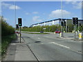
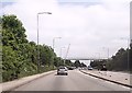
Traffic lights on the A38
Heading west towards Alfreton.
Image: © JThomas
Taken: 18 Apr 2014
0.08 miles
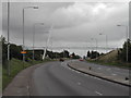
4
A38 Kings Road, Sutton in Ashfield (4)
Heading west towards the B6023 junction.
Image: © John Topping
Taken: 25 Jun 2013
0.13 miles
5
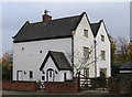
Sutton-in-Ashfield - Fulwood Farmhouse
The address of this building is 8, Fonton Hall Drive and the architectural style of the house suggests that this may have been called Fonton Hall in the past. It is listed as "Fulwood Farmhouse, Alfreton Road" in the register of listed buildings within the Ashfield District - see http://www.ashfield-dc.gov.uk/ccm/navigation/environment/planning/development-advice---control/listed-buildings/sutton-area/11--fulwood-farmhouse--alfreton-road--sutton-/ and
http://www.britishlistedbuildings.co.uk/en-410949-fulwood-farmhouse-nottinghamshire .
Image: © Dave Bevis
Taken: 1 Nov 2010
0.13 miles
6
Footbridge over A38 near Sutton in Ashfield
Image: © John Firth
Taken: 9 Jun 2013
0.15 miles
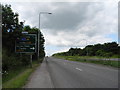
7
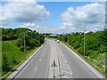
A38 Kings Road, Sutton in Ashfield (3)
View west from the footbridge.
Image: © John Topping
Taken: 25 Jun 2013
0.16 miles
8
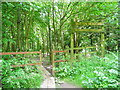
Sutton Meadows (1)
Sutton in Ashfield, Nottingham County Council. Path leading into the Meadows from the Kings Road footbridge. Path not shown on the 2005 Ex 269 map.
Image: © John Topping
Taken: 25 Jun 2013
0.16 miles
9
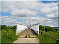
Footbridge over the A38 Kings Road, Sutton in Ashfield
Leading to Orcnard Way (Industrial estate).
Image: © John Topping
Taken: 25 Jun 2013
0.19 miles
10
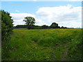
Sutton Meadows (2)
Viewed from the Kings Road to Bloomer Wood footpath.
Image: © John Topping
Taken: 25 Jun 2013
0.19 miles