1
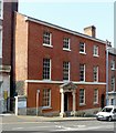
30 Park Row, Nottingham
Early 19th century town house, now offices, Listed Grade II.
Image: © Alan Murray-Rust
Taken: 8 Apr 2019
0.01 miles
2
Nottingham, NG1
A south-westerly view across the Standard Hill area towards the former British Waterways building - SK 571 392 - from the top floor of an NCP car park. The dominant building on the right is Royal Standard House, an apartment block converted from the former Nurses' Home of the former General Hospital.
Image: © David Hallam-Jones
Taken: 26 Nov 2012
0.02 miles
3
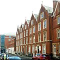
30-32 Park Row, Nottingham
A handsome pair of red brick early C19th houses. No. 32, Prince's House, has a chequer brick appearance and Tuscan porch. Both grade II listed.
Beyond, on Regent Street, is part of Thomas Chambers Hine's terrace of the 1850s, shaped gables and frilly window details. Grade II listed.
Image: © Stephen Richards
Taken: 19 Jun 2012
0.02 miles
4
Prince's House, Park Row, Nottingham
Early 19th century town house, Listed Grade II.
Image: © Alan Murray-Rust
Taken: 8 Apr 2019
0.02 miles
5
1 ? 5 Regent Street, Nottingham
3 houses, now offices. Early C19, restored late C20. Brick, with painted ground floor and ashlar dressings, Listed Grade II.
Image: © Alan Murray-Rust
Taken: 8 Apr 2019
0.02 miles
6
Doorways, 2 ? 4 Regent Street, Nottingham
The right hand doorway retains its original panelled door and fanlight. See http://www.geograph.org.uk/photo/6117463 for location.
Image: © Alan Murray-Rust
Taken: 8 Apr 2019
0.02 miles
7
Jacobean gables on Regent Street
The terrace on the left, designed by T C Hine, was built in the 1850s and is Grade II listed. In the distance are some of the undistinguished blocks inflicted on the city in the 1960s. The city fathers thought Maid Marian Way looked like progress. Most Nottinghamians thought it looked awful.
Image: © John Sutton
Taken: 21 May 2021
0.03 miles
8
2 ? 12 Regent Street, Nottingham
6 terraced houses, now offices. c1854-58. By TC Hine of Nottingham. Restored late C20. Red brick, with painted ashlar dressings and slate roofs, Listed Grade II. Although contemporary with nos.14-24 by the same architect, Hine clearly chose to vary the design rather than create a long continuous terrace.
Image: © Alan Murray-Rust
Taken: 8 Apr 2019
0.03 miles
9
7 ? 15 Regent Street, Nottingham
5 terraced houses, now offices, and attached area railings, steps and gate piers. 1850-54. By TC Hine of Nottingham. Restored late C20. Red brick, with painted ashlar dressings, Listed Grade II. Noticeably restrained compared with Hine's two terraces on the opposite side of the road.
Image: © Alan Murray-Rust
Taken: 8 Apr 2019
0.04 miles
10
Former Children's Hospital
On the corner of Park Row and The Ropewalk. This is where I lost my tonsils in 1954.
Image: © John Sutton
Taken: 21 Nov 2009
0.05 miles


