IMAGES TAKEN NEAR TO
Sherwood Way, NOTTINGHAM, NG16 6PZ
Introduction
This page details the photographs taken nearby to Sherwood Way, NG16 6PZ by members of the Geograph project.
The Geograph project started in 2005 with the aim of publishing, organising and preserving representative images for every square kilometre of Great Britain, Ireland and the Isle of Man.

There are currently over 7.5m images from over14,400 individuals and you can help contribute to the project by visiting https://www.geograph.org.uk
Image Map
Images are licensed for reuse under creativecommons.org/licenses/by-sa/2.0
Notes
- Clicking on the map will re-center to the selected point.
- The higher the marker number, the further away the image location is from the centre of the postcode.
Image Listing (18 Images Found)
Images are licensed for reuse under creativecommons.org/licenses/by-sa/2.0
Image
Details
Distance
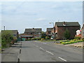
2
Period Dwellings at Annesley Lane End
Image: © Jonathan Clitheroe
Taken: 15 Jul 2022
0.15 miles
3
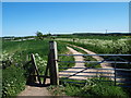
Notts - NG16 (Annesley Lane End)
This footpath commences (or finishes) on the right-hand side of Annesley Lane, just before Annesley Lane crosses the M1 motorway and thereafter becomes Salmon Lane. As can be seen here the footpath runs almost parallel with the motorway and thus a ramble through this arable farmland cannot be guaranteed to be a quiet one. The other end (or the beginning) of the path leads walkers out onto the side of the A608, near to the Sherwood Business Park.
Image: © David Hallam-Jones
Taken: 26 May 2012
0.16 miles
4
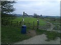
Footpath Junction at Annesley Lane End
The M1 motorway roars across the mid-horizon yet the crooked finger-post in the foreground quite possibly pre-dates it.
Image: © Jonathan Clitheroe
Taken: 5 Jan 2019
0.18 miles
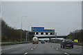
6

Ashfield : M1 Motorway
The M1 Motorway between Junction 27 and Junction 28.
Image: © Lewis Clarke
Taken: 30 Sep 2018
0.20 miles
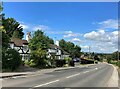
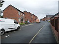
7
West end of Sherwood Way, Selston
Seen from Portland Road.
Image: © Richard Vince
Taken: 21 Apr 2018
0.21 miles
8
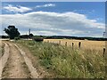
Farm Track and Footpath close to the M1 Motorway
Fields of barley are all that separate this rural view from the busy trunk road ahead.
Image: © Jonathan Clitheroe
Taken: 15 Jul 2022
0.21 miles
9
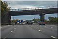
Ashfield : M1 Motorway
The M1 Motorway between Junction 28 and Junction 27.
Image: © Lewis Clarke
Taken: 3 Oct 2018
0.22 miles
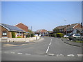
10
Sovereign Gardens, off Portland Road
A newish infill development, between Victoria Street and Upper Mexborough Road.
Image: © Christine Johnstone
Taken: 19 Aug 2017
0.22 miles