IMAGES TAKEN NEAR TO
Pennine Drive, NOTTINGHAM, NG16 6GT
Introduction
This page details the photographs taken nearby to Pennine Drive, NG16 6GT by members of the Geograph project.
The Geograph project started in 2005 with the aim of publishing, organising and preserving representative images for every square kilometre of Great Britain, Ireland and the Isle of Man.

There are currently over 7.5m images from over14,400 individuals and you can help contribute to the project by visiting https://www.geograph.org.uk
Image Map
Images are licensed for reuse under creativecommons.org/licenses/by-sa/2.0
Notes
- Clicking on the map will re-center to the selected point.
- The higher the marker number, the further away the image location is from the centre of the postcode.
Image Listing (9 Images Found)
Images are licensed for reuse under creativecommons.org/licenses/by-sa/2.0
Image
Details
Distance

6
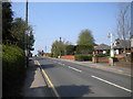
South east end of Common Side, Selston
Image: © Richard Vince
Taken: 21 Apr 2018
0.20 miles
8
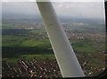
Selston, from Underwood: aerial 2014
Looking northwards.
Taken from the wrong side of the aeroplane, but still worth a look, this shows the array of small former mining communities west of the M1 (which can be seen in the top right quarter, running diagonally upwards and to the left).
Underwood at the bottom, then Selston and Pinxton.
Underwood Community Centre and Recreation Ground bottom right.
Image: © Chris
Taken: 9 Apr 2014
0.21 miles
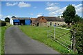
9
Pippin Close, off Portland Road
A newish infill estate, dropping down the hillside.
Image: © Christine Johnstone
Taken: 19 Aug 2017
0.25 miles