IMAGES TAKEN NEAR TO
Church Lane, NOTTINGHAM, NG16 6EX
Introduction
This page details the photographs taken nearby to Church Lane, NG16 6EX by members of the Geograph project.
The Geograph project started in 2005 with the aim of publishing, organising and preserving representative images for every square kilometre of Great Britain, Ireland and the Isle of Man.

There are currently over 7.5m images from over14,400 individuals and you can help contribute to the project by visiting https://www.geograph.org.uk
Image Map
Images are licensed for reuse under creativecommons.org/licenses/by-sa/2.0
Notes
- Clicking on the map will re-center to the selected point.
- The higher the marker number, the further away the image location is from the centre of the postcode.
Image Listing (34 Images Found)
Images are licensed for reuse under creativecommons.org/licenses/by-sa/2.0
Image
Details
Distance
2
Its 30 for a reason on Church Lane, Selston Green
Presumably the sign is a response to speeding cars. Looking south-west.
Image: © Christine Johnstone
Taken: 19 Aug 2017
0.05 miles
3
St Helen's Drive, Selston Green
A fairly new residential cul-de-sac behind the houses on the south side of Church Lane. The church is dedicated to St Helen.
Image: © Christine Johnstone
Taken: 19 Aug 2017
0.07 miles
4
Beech Court Care Home, Church Lane, Selston
Caring for up to 23 people over the age of 55.
Image: © Christine Johnstone
Taken: 19 Aug 2017
0.10 miles
5
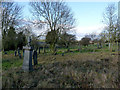
Church of St Helen, Selston
The graveyard to the west of the church. Lack of housing to the west and north of the medieval churchyard enabled continuous expansion during the 19th and 20th centuries without the need to create a new cemetery.
Image: © Alan Murray-Rust
Taken: 30 Nov 2014
0.10 miles
7
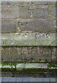
Bench mark, St Helen's Church Selston
See http://www.geograph.org.uk/photo/4265937 for location.
Image: © Alan Murray-Rust
Taken: 5 Dec 2014
0.11 miles
8
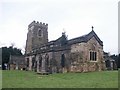
Church of St Helen, Selston
The tower seen from the south west.
There is a bench mark http://www.geograph.org.uk/photo/4272905 on the south face of the tower.
Image: © Alan Murray-Rust
Taken: 30 Nov 2014
0.11 miles
9
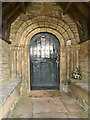
Church of St Helen, Selston
South doorway in late Norman/Transitional style.
Image: © Alan Murray-Rust
Taken: 30 Nov 2014
0.11 miles
10
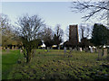
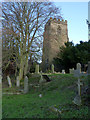
Church of St Helen, Selston
The graveyard looking east towards the church.
Image: © Alan Murray-Rust
Taken: 30 Nov 2014
0.11 miles