IMAGES TAKEN NEAR TO
The Orchards, NOTTINGHAM, NG16 5QL
Introduction
This page details the photographs taken nearby to The Orchards, NG16 5QL by members of the Geograph project.
The Geograph project started in 2005 with the aim of publishing, organising and preserving representative images for every square kilometre of Great Britain, Ireland and the Isle of Man.

There are currently over 7.5m images from over14,400 individuals and you can help contribute to the project by visiting https://www.geograph.org.uk
Image Map
Images are licensed for reuse under creativecommons.org/licenses/by-sa/2.0
Notes
- Clicking on the map will re-center to the selected point.
- The higher the marker number, the further away the image location is from the centre of the postcode.
Image Listing (18 Images Found)
Images are licensed for reuse under creativecommons.org/licenses/by-sa/2.0
Image
Details
Distance
1
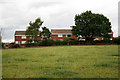
Houses on the edge of Jacksdale
They may actually officially be in Westwood.
Image: © David Lally
Taken: 31 Jul 2010
0.13 miles
2
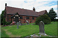
St Mary's, Westwood
Consecrated on September 9th, 1899.
Image: © David Lally
Taken: 31 Jul 2010
0.13 miles
3
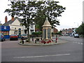
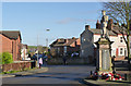
War Memorial, Main Road, Jacksdale, Nottinghamshire
Jacksdale is a former coal mining village situated in the Erewash Valley, on the Nottinghamshire-Derbyshire border. The War Memorial is in the centre of the village, near all the shops and services, at the junction of Wagstaff Lane with Main Road. It is unusual, in that it not only commemorates those from the parish who fell in the Great War of 1914-18 on one panel but also lists all those who served in the armed forces during the same conflict, on the other three panels. The fallen from the Second World War of 1939-45 are commemorated on the smaller panels around its base. Pye Hill pit, the last mine in the area, closed in 1985. A colliery winding wheel across the road from the War Memorial, commemorates the village's strong links with coal mining.
Image: © Alan Slater
Taken: 26 Jun 2006
0.13 miles
4
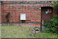
East wall of St Mary's, Westwood
With features of various ages. A water pump and gas meter and a half overgrown door.
Image: © David Lally
Taken: 31 Jul 2010
0.13 miles
5
Jacksdale War Memorial
The sculpture of a soldier was installed in 2009. It is a replica of the original sculpture which was blown off the pedestal in a storm in 1959 and shattered. The monument is relatively unusual in recording the names of all those who served during World War 1, not just those who lost their lives. It was installed in 1921.
Update: The memorial was Listed Grade II in 2016
Image: © Alan Murray-Rust
Taken: 30 Nov 2014
0.15 miles
6
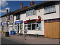
Jacksdale: the post office
The position of the postbox - in the wall of the shop next door - suggests perhaps that the post office was once larger, occupying both frontages. This would appear to be supported by the large-scale mapping, which appears to mark 'PO' across a larger area than just this right-hand shop.
Image: © Chris Downer
Taken: 26 Apr 2013
0.15 miles
7
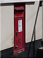
Jacksdale: postbox № NG16 309, Main Road
This George VI-reign postbox is set into the wall of Image - in fact, in the wall of the shop next door, perhaps suggesting that the post office once occupied both premises.
Image: © Chris Downer
Taken: 26 Apr 2013
0.15 miles
8
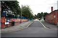
Church Hill
I think I'm in Jacksdale, but the church which is a couple of hundred yards up the hill is referred to as St Mary's, Westwood. All very confusing.
Image: © David Lally
Taken: 31 Jul 2010
0.16 miles
9
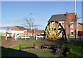
Jacksdale Community Centre memorial garden
The half pit-sheave is a reminder that this was once a mining community; it came from the nearby Pye Bridge Colliery.
Image: © Alan Murray-Rust
Taken: 30 Nov 2014
0.16 miles
10
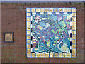
Jacksdale Parish Map
A ceramic mosaic created with the help of local children, on the wall of the Community Centre. Not the easiest map to read, but it is actually cartographically pretty accurate.
Image: © Alan Murray-Rust
Taken: 30 Nov 2014
0.17 miles