IMAGES TAKEN NEAR TO
Forge Row, NOTTINGHAM, NG16 5PG
Introduction
This page details the photographs taken nearby to Forge Row, NG16 5PG by members of the Geograph project.
The Geograph project started in 2005 with the aim of publishing, organising and preserving representative images for every square kilometre of Great Britain, Ireland and the Isle of Man.

There are currently over 7.5m images from over14,400 individuals and you can help contribute to the project by visiting https://www.geograph.org.uk
Image Map
Images are licensed for reuse under creativecommons.org/licenses/by-sa/2.0
Notes
- Clicking on the map will re-center to the selected point.
- The higher the marker number, the further away the image location is from the centre of the postcode.
Image Listing (53 Images Found)
Images are licensed for reuse under creativecommons.org/licenses/by-sa/2.0
Image
Details
Distance
1
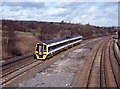
Passenger train at Codnor Park - 1995
A southbound 158 unit at Codnor Park, south of Chesterfield.
Image: © The Carlisle Kid
Taken: 15 Mar 1995
0.07 miles
2
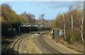
Erewash Valley railway line, Codnor Park
Looking north from Station Lane bridge.
The signalling on the gantry includes junction indicators for Pye Bridge junction where a line to Mansfield splits from the main line. All three tracks here are signalled for bi-directional operation.
The bridge abutments in the foreground carried the Butterley Company's main line into the Codnorpark ironworks with a connection onto the Erewash Valley line at Codnorpark Station.
Image: © Alan Murray-Rust
Taken: 30 Nov 2018
0.08 miles
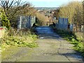
3
Station Lane Bridge, Codnor Park
The rail authority notice http://www.geograph.org.uk/photo/5993235 locates this bridge at Jacksdale, although it is on the other side of the River Erewash, and in a different County.
Image: © Alan Murray-Rust
Taken: 30 Nov 2018
0.09 miles
4
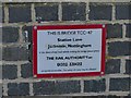
Station Lane Bridge, Codnor Park, notice
The location is incorrectly addressed as Jacksdale, rather than Codnor or Ironville. Jacksdale is actually in a different County. Clearly someone local has taken objection and tried to obliterate the name.
Image: © Alan Murray-Rust
Taken: 30 Nov 2018
0.09 miles
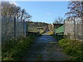
5
Station Lane, Codnor Park
This was once the main road entrance into the extensive Codnor Park ironworks, and also provided access to Codnorpark Station.
Image: © Alan Murray-Rust
Taken: 30 Nov 2018
0.09 miles
7
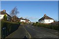
New Road, Codnor Park
Part of the inter-war expansion of housing in the area.
Image: © Alan Murray-Rust
Taken: 30 Nov 2018
0.10 miles
8
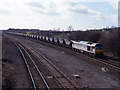
Coal train at Codnor Park - 1995
Diesel locomotive 60088 brings a train of coal hoppers towards the site of Codnor Park station, south of Chesterfield.
Image: © The Carlisle Kid
Taken: 15 Mar 1995
0.12 miles
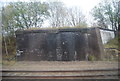
9
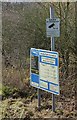
Access Point Information
The site is named as Codnor Old Station, although the station name was always Codnor Park & Ironville.
Image: © Alan Murray-Rust
Taken: 30 Nov 2018
0.12 miles
10
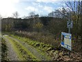
Site of Codnor Park & Ironville Station
Now a maintenance access point.
Image: © Alan Murray-Rust
Taken: 30 Nov 2018
0.12 miles