IMAGES TAKEN NEAR TO
Church Lane, NOTTINGHAM, NG16 5HD
Introduction
This page details the photographs taken nearby to Church Lane, NG16 5HD by members of the Geograph project.
The Geograph project started in 2005 with the aim of publishing, organising and preserving representative images for every square kilometre of Great Britain, Ireland and the Isle of Man.

There are currently over 7.5m images from over14,400 individuals and you can help contribute to the project by visiting https://www.geograph.org.uk
Image Map
Images are licensed for reuse under creativecommons.org/licenses/by-sa/2.0
Notes
- Clicking on the map will re-center to the selected point.
- The higher the marker number, the further away the image location is from the centre of the postcode.
Image Listing (14 Images Found)
Images are licensed for reuse under creativecommons.org/licenses/by-sa/2.0
Image
Details
Distance
1
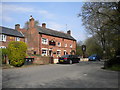
Notts - NG16 (Bagthorpe)
This view of the stretch of road connecting Underwood village with Lower Bagthorpe gives a good idea of the half residential/half rural flavour of the lower end of Church Lane and the more upmarket nature of the housing stock, compared with the terraced housing that is found at the other end of this long road in the former pit village of Underwood.
Image: © David Hallam-Jones
Taken: 26 May 2012
0.03 miles
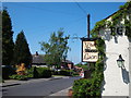
2
Notts - NG16 (Bagthorpe)
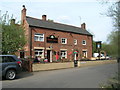
An exceptionally large garden and a children's play area would appear to make up for the 'cosy' size of this 17th century (at least in the summer ?) This is the "Red Lion" pub as seen from the Lower Bagthorpe end of Church Lane.
Image: © David Hallam-Jones
Taken: 26 May 2012
0.06 miles
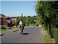
3
Notts - NG16 (Bagthorpe)
By the time an observer has reached here on Church Lane and finds him/herself looking downhill in the direction of Lower Bagthorpe, the supply of terraced houses associated with the former mining community of Underwood, has disappeared from the housing stock and has been replaced by larger, more modern detached and semi-detached properties. An exceptionally large garden and children's play area to the side and rear of this 17th century pub appear to make up for its 'cosy' size (at least in the summer).
Image: © David Hallam-Jones
Taken: 26 May 2012
0.06 miles
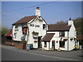
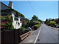
5
Red Lion, Bagthorpe
17th Century pub with extensions.
As newcomers to the area, we were pleasantly surprised to see so many of the old pubs still open.
Image: © Chris
Taken: 1 Nov 2014
0.07 miles
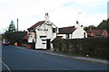
6
Dixies Arms
This pub in Bagthorpe has the unusual name of Dixies Arms.
Image: © Michael Patterson
Taken: 7 Apr 2006
0.13 miles
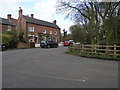
8
Notts - NG16 (Lower Bagthorpe)
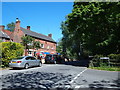
The Dixies Arms pub is perhaps the most prominent feature of this junction where Church Lane meets School Road in Lower Bagthorpe. According to records the tithes of local people were previously “impropriated to the Lady Dixie, liyeing (sic) in the parish of Selston”. Thus it seems this pub, or the land upon which it was built, may once have belonged to this landowner.
Image: © David Hallam-Jones
Taken: 26 May 2012
0.13 miles