IMAGES TAKEN NEAR TO
Sharrard Close, NOTTINGHAM, NG16 5EQ
Introduction
This page details the photographs taken nearby to Sharrard Close, NG16 5EQ by members of the Geograph project.
The Geograph project started in 2005 with the aim of publishing, organising and preserving representative images for every square kilometre of Great Britain, Ireland and the Isle of Man.

There are currently over 7.5m images from over14,400 individuals and you can help contribute to the project by visiting https://www.geograph.org.uk
Image Map
Images are licensed for reuse under creativecommons.org/licenses/by-sa/2.0
Notes
- Clicking on the map will re-center to the selected point.
- The higher the marker number, the further away the image location is from the centre of the postcode.
Image Listing (25 Images Found)
Images are licensed for reuse under creativecommons.org/licenses/by-sa/2.0
Image
Details
Distance
1
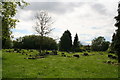
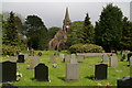
Underwood's large churchyard
Graves old and new, and plenty of room for more.
Image: © Chris
Taken: 13 May 2014
0.07 miles
2
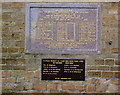
Pye Hill Colliery Memorial, Underwood Church
Dedicated in 1985. The plaque implies that the memorial is specifically to the Colliery rather than its workforce, and the churchyard seems an unusual location for it.
Image: © Alan Murray-Rust
Taken: 5 Dec 2014
0.10 miles
3
Large churchyard, Underwood
Graves old and new, and plenty of room for more.
Image: © Chris
Taken: 13 May 2014
0.11 miles
4
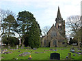
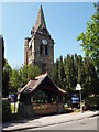
Church of St Michael and All Angels, Underwood
Viewed from the west. The church was built in 1890 for Earl Cowper, the main local landowner, designed by J A Chatwin. The church is in the 14th century Decorated style, with geometric tracery. Listed Grade II.
Image: © Alan Murray-Rust
Taken: 5 Dec 2014
0.11 miles
5
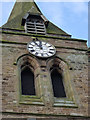
Church of St Michael and All Angels, Underwood
The clock, installed as a memorial to the dead of the First World War http://www.geograph.org.uk/photo/4272901
Image: © Alan Murray-Rust
Taken: 5 Dec 2014
0.12 miles
6
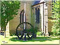
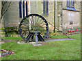
Pye Hill Colliery Headstock Memorial, Underwood
The wheel from the headstock stands as a tribute to the importance to Underwood of the mining industry and the plaque on the headstock reads "A memorial to Pye Hill Number 1 Colliery dedicated by the Bishop of Sherwood the Rt. Reverend R. Darby on 28th September 1985."
Image: © Garth Newton
Taken: 26 Aug 2005
0.12 miles
7
Church of St Michael and All Angels, Underwood
War memorial tablets on the east end. The upper tablet commemorates the dead of the First World War, both the church clock and the east window above the tablet forming part of the memorial.
Image: © Alan Murray-Rust
Taken: 5 Dec 2014
0.12 miles
8
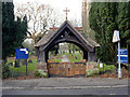
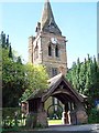
Church of St Michael and All Angels, Underwood
The lych gate. Built at the same time as the church (1890), designed by J A Chatwin. Listed Grade II separately from the church.
Image: © Alan Murray-Rust
Taken: 5 Dec 2014
0.12 miles
9
Notts - NG16 (Underwood)
St Michael and All Angels' Anglican Church is located at the Alfreton Road end of Church Lane, a stone's throw away from the Underwood Miners' Welfare Club premises. Mounted as a memorial immediately inside the lych gate is the pithead winding wheel from the Pye Hill (No.1) Colliery, installed here in 1985.
Image: © David Hallam-Jones
Taken: 26 May 2012
0.13 miles
10
Underwood Church and Lychgate
The church and lychgate were designed by the Birmingham 'Gothic' architect, J. A. Chatwin in the style of the 14th century. They were erected in 1889 after being commissioned at a cost of £5000 by the 7th Earl Cowper who was a British Liberal politician and also served as Lord Lieutenant of Ireland between 1880 and 1882. The church dedicated to St Michael & All Angels had the clock installed in 1920 as a memorial to the local men who died in the First World War. The spire is visible from the surrounding countryside and is notable for being covered by oak shingles.
Image: © Garth Newton
Taken: 26 Aug 2005
0.14 miles