IMAGES TAKEN NEAR TO
Kings Drive, NOTTINGHAM, NG16 5DG
Introduction
This page details the photographs taken nearby to Kings Drive, NG16 5DG by members of the Geograph project.
The Geograph project started in 2005 with the aim of publishing, organising and preserving representative images for every square kilometre of Great Britain, Ireland and the Isle of Man.

There are currently over 7.5m images from over14,400 individuals and you can help contribute to the project by visiting https://www.geograph.org.uk
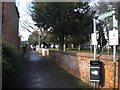
Image Map
Images are licensed for reuse under creativecommons.org/licenses/by-sa/2.0
Notes
- Clicking on the map will re-center to the selected point.
- The higher the marker number, the further away the image location is from the centre of the postcode.
Image Listing (17 Images Found)
Images are licensed for reuse under creativecommons.org/licenses/by-sa/2.0
Image
Details
Distance
1
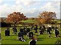
Brinsley churchyard extension
This was created to the west of the church in 1996.
At the far end a pair of oak trees showing golden autumn colour.
Image: © Alan Murray-Rust
Taken: 12 Nov 2018
0.09 miles
2
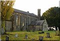
Church of St James the Great, Brinsley
Built in 1838 as a single rectangular space, forming a chapel of ease for the parish of Greasley. With the growth of population due to the coal mining industry, the parish of Brinsley was formed in 1861; the chancel was added in 1878. The vestry was formed from the original north porch in 1913 and further enlarged later. Listed Grade II.
Image: © Alan Murray-Rust
Taken: 12 Nov 2018
0.09 miles
3
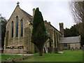
Church of St James the Great, Brinsley
View of the church from the west. (You can see bits of the church if you look carefully!)
Image: © Alan Murray-Rust
Taken: 12 Nov 2018
0.09 miles
4
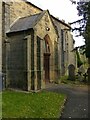
Church of St James the Great, Brinsley
The south porch.
Image: © Alan Murray-Rust
Taken: 12 Nov 2018
0.09 miles
5
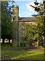
Church of St James the Great, Brinsley
The west end of the church showing one of the pair of octagonal turrets. This one served as a chimney to the heating boiler. The church is well surrounded with trees and difficult to photograph.
Image: © Alan Murray-Rust
Taken: 12 Nov 2018
0.09 miles
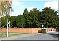
6
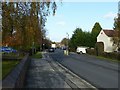
Church Lane, Brinsley
The A608 linking Eastwood with Mansfield.
Image: © Alan Murray-Rust
Taken: 12 Nov 2018
0.10 miles
7
Brinsley churchyard
The church of St James the Great hides behind a screen of trees.
Image: © Alan Murray-Rust
Taken: 12 Nov 2018
0.10 miles
8
The Church of St James The Great , Brinsley
Image: © Bill Henderson
Taken: 29 Mar 2008
0.11 miles
9
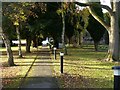
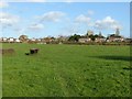
Public footpath, Brinsley
Off Church Lane, along the southern edge of the churchyard.
Image: © Richard Vince
Taken: 24 Feb 2015
0.12 miles
10
Footpath at Brinsley
Looking towards the church.
Image: © Alan Murray-Rust
Taken: 12 Nov 2018
0.13 miles