IMAGES TAKEN NEAR TO
Moor Road, NOTTINGHAM, NG16 5AZ
Introduction
This page details the photographs taken nearby to Moor Road, NG16 5AZ by members of the Geograph project.
The Geograph project started in 2005 with the aim of publishing, organising and preserving representative images for every square kilometre of Great Britain, Ireland and the Isle of Man.

There are currently over 7.5m images from over14,400 individuals and you can help contribute to the project by visiting https://www.geograph.org.uk
Image Map
Images are licensed for reuse under creativecommons.org/licenses/by-sa/2.0
Notes
- Clicking on the map will re-center to the selected point.
- The higher the marker number, the further away the image location is from the centre of the postcode.
Image Listing (11 Images Found)
Images are licensed for reuse under creativecommons.org/licenses/by-sa/2.0
Image
Details
Distance
1
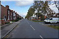
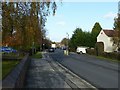
Broad Lane Brinsley
Broad Lane is a long straight road with a variety of different types of housing on both sides.
Image: © Malcolm Neal
Taken: 4 Nov 2021
0.08 miles
2
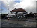
Brinsley Fish Bar
Still an impressive piece of domestic art deco architecture, despite the curved windows having been replaced with flat panes.
Image: © Richard Vince
Taken: 24 Feb 2015
0.10 miles
3
Cordy Lane, Brinsley
Looking along the A608 towards Mansfield, close to the northern edge of Brinsley.
Image: © Richard Vince
Taken: 24 Feb 2015
0.13 miles
4
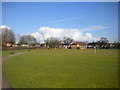
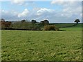
Brinsley Recreation Ground
A sizable playing field in a bend in the A608, at around the point at which Brinsley meets New Brinsley. It was somewhat soggy on this occasion, having been freshly and comprehensively rained on.
Image: © Richard Vince
Taken: 24 Feb 2015
0.14 miles
5

Clean new bus
Opposite our address. The white building (left corner) is the chip-shop.
Image: © Graham
Taken: 3 Dec 2006
0.21 miles
6
Church Lane, Brinsley
The A608 linking Eastwood with Mansfield.
Image: © Alan Murray-Rust
Taken: 12 Nov 2018
0.22 miles
7
View towards Brinsley Moor
From the footpath between Brinsley Church and Hall Lane
Image: © Alan Murray-Rust
Taken: 12 Nov 2018
0.22 miles
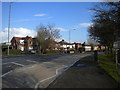
8
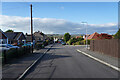
Hobsic Close
This is one of several cul-de-sac roads with a curve in them on the edge of New Brinsley.
Image: © Malcolm Neal
Taken: 4 Nov 2021
0.23 miles
9
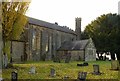
Church of St James the Great, Brinsley
Built in 1838 as a single rectangular space, forming a chapel of ease for the parish of Greasley. With the growth of population due to the coal mining industry, the parish of Brinsley was formed in 1861; the chancel was added in 1878. The vestry was formed from the original north porch in 1913 and further enlarged later. Listed Grade II.
Image: © Alan Murray-Rust
Taken: 12 Nov 2018
0.24 miles
10
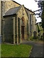
Church of St James the Great, Brinsley
The south porch.
Image: © Alan Murray-Rust
Taken: 12 Nov 2018
0.25 miles