IMAGES TAKEN NEAR TO
Hall Lane, NOTTINGHAM, NG16 5AH
Introduction
This page details the photographs taken nearby to Hall Lane, NG16 5AH by members of the Geograph project.
The Geograph project started in 2005 with the aim of publishing, organising and preserving representative images for every square kilometre of Great Britain, Ireland and the Isle of Man.

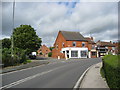
There are currently over 7.5m images from over14,400 individuals and you can help contribute to the project by visiting https://www.geograph.org.uk
Image Map
Images are licensed for reuse under creativecommons.org/licenses/by-sa/2.0
Notes
- Clicking on the map will re-center to the selected point.
- The higher the marker number, the further away the image location is from the centre of the postcode.
Image Listing (45 Images Found)
Images are licensed for reuse under creativecommons.org/licenses/by-sa/2.0
Image
Details
Distance
1
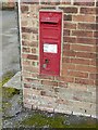
Postbox, Hall Lane, Brinsley
VR wall box with narrow posting slit, ref.NG16 108
See http://www.geograph.org.uk/photo/5976035 for location.
Image: © Alan Murray-Rust
Taken: 12 Nov 2018
0.04 miles
2
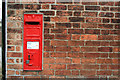
Victorian wall postbox
On Hall Lane Brinsley.
Image: © David Lally
Taken: 5 Sep 2010
0.04 miles
3
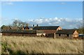
Manor Farm, Brinsley
Victorian farmstead, clearly built as a single development. A feature is the use of decorative polychrome brickwork. The farm outbuildings appear to have been converted for residential use
Image: © Alan Murray-Rust
Taken: 12 Nov 2018
0.05 miles
4
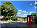
Telephone Box on Hall Lane in Brinsley
This scenically placed example is now a mini-library.
Image: © Jonathan Clitheroe
Taken: 5 Jul 2022
0.06 miles
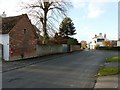
5
Brinsley - Lane Junction
Mansfield Road becomes Church Lane at Hall Lane junction.
Image: © Alan Heardman
Taken: 31 Aug 2009
0.07 miles
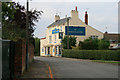
7
The old White Lion, Brinsley
Now trading as The Lion at Brinsley, a specialised restaurant rather than a pub.
Image: © Alan Murray-Rust
Taken: 12 Nov 2018
0.08 miles
8
Hall Lane, Brinsley
Victorian postbox http://www.geograph.org.uk/photo/5976034 in the building on the left, the old White Lion pub in the distance.
Image: © Alan Murray-Rust
Taken: 12 Nov 2018
0.08 miles
9
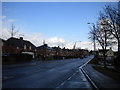
Church Lane, Brinsley (1)
Looking north, from close to the southern edge of Brinsley, along the A608 towards Mansfield.
Image: © Richard Vince
Taken: 24 Feb 2015
0.08 miles
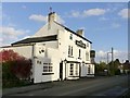
10
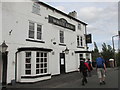
The White Lion public house.
Almost back to the car on a walk from Brinsley.
Image: © steven ruffles
Taken: 13 Oct 2018
0.08 miles