IMAGES TAKEN NEAR TO
Mansfield Road, NOTTINGHAM, NG16 5AE
Introduction
This page details the photographs taken nearby to Mansfield Road, NG16 5AE by members of the Geograph project.
The Geograph project started in 2005 with the aim of publishing, organising and preserving representative images for every square kilometre of Great Britain, Ireland and the Isle of Man.

There are currently over 7.5m images from over14,400 individuals and you can help contribute to the project by visiting https://www.geograph.org.uk
Image Map
Images are licensed for reuse under creativecommons.org/licenses/by-sa/2.0
Notes
- Clicking on the map will re-center to the selected point.
- The higher the marker number, the further away the image location is from the centre of the postcode.
Image Listing (49 Images Found)
Images are licensed for reuse under creativecommons.org/licenses/by-sa/2.0
Image
Details
Distance
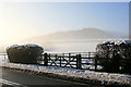
1
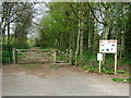
Entrance to Brinsley Headstocks
The entry up to the headstocks and park is via the disused railway, now a gravel track.
Image: © John Poyser
Taken: 27 Apr 2008
0.03 miles
2
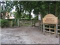
Brinsley Headstocks Car Park
Starting point for several walks in the area.
Image: © Alan Heardman
Taken: 31 Aug 2009
0.04 miles
3
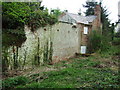
Rear of Vine Cottage
This is now a derelict cottage.
Image: © John Poyser
Taken: 27 Apr 2008
0.05 miles
4
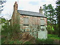
Vine Cottage
This derelict cottage was once lived in by an aunt of the author D. H. Lawrence.
Image: © John Poyser
Taken: 27 Apr 2008
0.06 miles
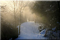
5
Snow-capped hedge
Beside the A608, Mansfield Road on the outskirts of Brinsley, The landscaped spoil heap from the area's coal-mining past now could pass as a natural hill.
Image: © David Lally
Taken: 5 Dec 2010
0.06 miles
6
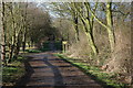
Disused Railway Line Walk next to Headstocks
wonderful walk next to the headstocks at Brinsley, if you are lucky you might even see a kingfisher.
Image: © Team Dawson
Taken: 1 Apr 2006
0.08 miles
7
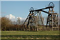
Brinsley Headstocks
Brinsley headstocks from another angle, you don't realise just how big they are until you are close up to them.
Image: © Team Dawson
Taken: 1 Apr 2006
0.08 miles
8
A small dip in the path
Where it crosses Brinsley Brook. The path appears to follow the line of a colliery railway, it is very straight and a bit further north there are a few signs indicating that is the case http://www.geograph.org.uk/photo/1466663 . It is not marked as such on the OS maps however.
Image: © David Lally
Taken: 5 Dec 2010
0.09 miles
10
Site of former Brinsley Colliery
The former Brinsley Colliery has now been transformed into a picnic area. Author D H Lawrence's father worked at the colliery and DHL, born in nearby Eastwood, used the location in "Sons and Lovers" calling it Begarlee.
Image: © Garth Newton
Taken: 26 Aug 2005
0.11 miles