IMAGES TAKEN NEAR TO
Victory Close, NOTTINGHAM, NG16 3TY
Introduction
This page details the photographs taken nearby to Victory Close, NG16 3TY by members of the Geograph project.
The Geograph project started in 2005 with the aim of publishing, organising and preserving representative images for every square kilometre of Great Britain, Ireland and the Isle of Man.

There are currently over 7.5m images from over14,400 individuals and you can help contribute to the project by visiting https://www.geograph.org.uk
Image Map
Images are licensed for reuse under creativecommons.org/licenses/by-sa/2.0
Notes
- Clicking on the map will re-center to the selected point.
- The higher the marker number, the further away the image location is from the centre of the postcode.
Image Listing (46 Images Found)
Images are licensed for reuse under creativecommons.org/licenses/by-sa/2.0
Image
Details
Distance
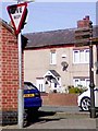
1
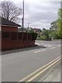
Give Way Junction
Give Way Junction On Walker Street In Eastwood Nottingham Nottinghamshire.
Image: © gary
Taken: 10 Jun 2019
0.02 miles
2
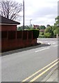
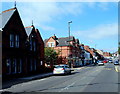
Looking Down Walker Street
Looking Down Walker Street In Eastwood Nottingham Nottinghamshire.
Image: © gary
Taken: 10 Aug 2019
0.03 miles
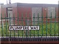
3
UK Back Of A No Entry Sign Pole
UK Back Of A No Entry Sign Pole On Plumptre Way Eastwood, Nottingham Nottinghamshire.
Image: © gary
Taken: 18 Jul 2019
0.04 miles
4
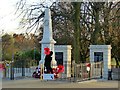
Eastwood War Memorial
The memorial was originally sited on a plot of land near to the Cemetery Chapel off Church Street (approximately 1 km away), but was moved to its present, more prominent, location in 1978. It was further transformed in 2010 with the addition of the wall and panels at the rear, the latter displaying names of victims of the First World War not recorded on the original obelisk. The railings round the obelisk were erected at the same time, replacing chain link fencing. The original elements of the memorial, originally dedicated in 1921, are Listed Grade II.
Image: © Alan Murray-Rust
Taken: 12 Nov 2018
0.04 miles
5
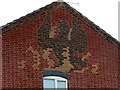
174 Nottingham Road, Eastwood
Detail of the Phoenix in polychrome brick. See http://www.geograph.org.uk/photo/5976067 for location.
Image: © Alan Murray-Rust
Taken: 12 Nov 2018
0.04 miles
6
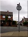
UK Give Way Sign
UK Give Way Sign On Plumptre Way Eastwood, Nottingham Nottinghamshire.
Image: © gary
Taken: 25 Mar 2019
0.05 miles
7
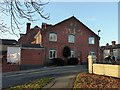
174 Nottingham Road, Eastwood
A commendable modern example of traditional brickwork, the whole side of the house, including the outhouse, being done in Flemish bond. Also incorporated is a polychrome brick rendering of the Phoenix symbol associated with D H Lawrence.
Image: © Alan Murray-Rust
Taken: 12 Nov 2018
0.05 miles
8
UK Street Road Sign
UK Street Road Sign On Plumptre Way, Eastwood, Nottingham Nottinghamshire.
Image: © gary
Taken: 23 Jul 2019
0.05 miles
9
Eastwood Library and loos
Alongside Nottingham Road in the main retail centre of Eastwood.
Image: © Alan Murray-Rust
Taken: 12 Nov 2018
0.06 miles
10
Eastwood Police Station - NG16
A view of the twin pitched-roofs on top of the police station. This "D Division" station is opposite the public library and this is the view along Nottingham Road towards Mansfield Road.
Image: © David Hallam-Jones
Taken: 7 Sep 2012
0.08 miles