IMAGES TAKEN NEAR TO
Mansfield Road, NOTTINGHAM, NG16 3SS
Introduction
This page details the photographs taken nearby to Mansfield Road, NG16 3SS by members of the Geograph project.
The Geograph project started in 2005 with the aim of publishing, organising and preserving representative images for every square kilometre of Great Britain, Ireland and the Isle of Man.

There are currently over 7.5m images from over14,400 individuals and you can help contribute to the project by visiting https://www.geograph.org.uk
Image Map
Images are licensed for reuse under creativecommons.org/licenses/by-sa/2.0
Notes
- Clicking on the map will re-center to the selected point.
- The higher the marker number, the further away the image location is from the centre of the postcode.
Image Listing (11 Images Found)
Images are licensed for reuse under creativecommons.org/licenses/by-sa/2.0
Image
Details
Distance
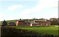
1
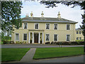
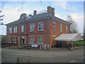
Eastwood Hall
Smart hotel and conference centre just off Mansfield Road. Strangely, the web site omits the interesting history of this building - http://www.eastwoodhallnottingham.co.uk/ .
The house was built in 1810 for the Plumptree family who owned the Plumptree Colliery just to the north. It was purchased by George Walker around 1830 as the family home. The Barber & Walker company by then owned and ran many collieries in the Eastwood area. The house was eventually acquired by the Barber & Walker company in 1916 and converted to their head office. The business partnership between the Barber and Walker families started in 1787 and it remained strong until the 1947 nationalisation of the coal industry. The new National Coal Board acquired the hall as their area office and it later became their headquarters. Planning for the national miners' strike of the 1980s took place here. The last coal mine in the area closed in 1985.
Image: © Trevor Rickard
Taken: 18 Jun 2011
0.03 miles
2
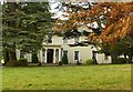
Eastwood Hall
Built in c.1810 by the Barber family, who came to run the local coal mining industry, it eventually passed to the National Coal Board, forming their regional offices, with extensive new build to the north of the house. Now a large conference and event centre. The original house is Listed Grade II.
Image: © Alan Murray-Rust
Taken: 12 Nov 2018
0.06 miles
3
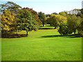
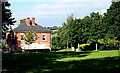
Parkland, Eastwood Hall
Eastwood Hall, formerly the headquarters of the National Coal Board and now a hotel and conference centre, is surrounded by mature parkland.
Image: © Tim Marchant
Taken: 10 Oct 2010
0.10 miles
4
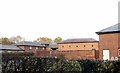
Hall Farm, Eastwood
Built as the home farm to Eastwood Hall, and early 19th century model farm which survives with little alteration. Converted to residential use c.2015, Listed Grade II.
A feature of the buildings is that all corners are constructed with bull-nose (rounded) bricks.
Image: © Alan Murray-Rust
Taken: 12 Nov 2018
0.13 miles
5
Hall Farm, Eastwood
Built as the home farm to Eastwood Hall, an early 19th century model farm which survives with little alteration. Converted to residential use c.2015, Listed Grade II.
Image: © Alan Murray-Rust
Taken: 12 Nov 2018
0.14 miles
6
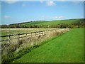
Farmland Near Eastwood Hall
A warm autumn afternoon. Looking northward towards Brinsley from Eastwood Hall grounds.
Image: © Tim Marchant
Taken: 10 Oct 2010
0.15 miles
7
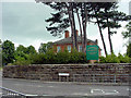
Durban House Heritage Centre
Corner of Greenhills Road. Pic by Tom
Image: © Q
Taken: 13 Jun 2005
0.16 miles
8
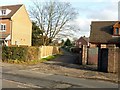
Bridleway off Mansfield Road, Eastwood
One of several tracks leading to Coneygrey Farm.
Image: © Alan Murray-Rust
Taken: 12 Nov 2018
0.18 miles
9
Durban House
Large house situated on Mansfield Road, which together with Image a short distance away makes up an interesting exhibition of the life and times of D H Lawrence. The building itself was built in 1896 as the administration offices for Barber Walker & Co, who ran the coal mines in the area until nationalisation in 1947.
http://www.lawrenceseastwood.co.uk/durbanhouse.htm
Image
Image: © Trevor Rickard
Taken: 14 Nov 2009
0.25 miles
10
Eastwood, Lawrence Heritage Museum - NG16
A view of one side of Durban House from the Mansfield Road Recreation Ground. This museum is situated on Mansfield Road on the corner of its junction with Greenhills Road. Durban House was built in 1896 for the Barber Walker mining company. It once housed the wages office for Brinsley Colliery, the colliery where D.H. Lawrence's father worked and it was here that the young D.H. (”Bert”) Lawrence would sometimes be sent to collect his father’s wage packet. Later on the house was turned into a mining institute, with a concert hall, billiard table and a library, before being converted into flats. More recently the house was left empty for several years, whereas nowadays it holds many of the Lawrence historical collections.
Image: © David Hallam-Jones
Taken: 8 Sep 2012
0.25 miles