IMAGES TAKEN NEAR TO
Meadowbank Way, NOTTINGHAM, NG16 3SR
Introduction
This page details the photographs taken nearby to Meadowbank Way, NG16 3SR by members of the Geograph project.
The Geograph project started in 2005 with the aim of publishing, organising and preserving representative images for every square kilometre of Great Britain, Ireland and the Isle of Man.

There are currently over 7.5m images from over14,400 individuals and you can help contribute to the project by visiting https://www.geograph.org.uk
Image Map
Images are licensed for reuse under creativecommons.org/licenses/by-sa/2.0
Notes
- Clicking on the map will re-center to the selected point.
- The higher the marker number, the further away the image location is from the centre of the postcode.
Image Listing (70 Images Found)
Images are licensed for reuse under creativecommons.org/licenses/by-sa/2.0
Image
Details
Distance
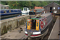
2
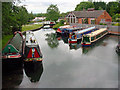
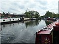
Great Northern Basin Langley Mill
The meeting point of the Cromford, Erewash and Nottingham canals. Restored and reopened 1973. Picture by Tom
Image: © Q
Taken: 13 Jun 2005
0.14 miles
3
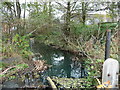
Paddle gear and weir on a Cromford Canal feeder stream
Helping to maintain the water level in the Great Northern basin at Langley Mill.
Image: © Christine Johnstone
Taken: 13 Nov 2017
0.16 miles
4
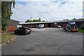
A small business estate
There are various small businesses around the Great Northern Basin. The basin is where the Erewash, Nottingham and Cromford Canals all met. The Nottingham canal is no longer in use and much of the Cromford canal is not under water.
Image: © Malcolm Neal
Taken: 18 Sep 2019
0.16 miles
5
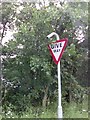
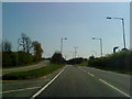
UK Give Way Sign
UK Give Way Sign joining the A610 Bypass at Langley Mill, Derbyshire.
Image: © gary
Taken: 15 Jul 2016
0.17 miles
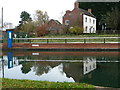
6
Dry Dock, Langley Mill
A dry dock for narrowboats is one facility available here at the northern end of the Erewash Canal.
Image: © Stephen McKay
Taken: 9 Sep 2007
0.17 miles
7
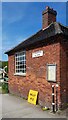
Toll House, Langly Mill
Beside the Erewash Canal (https://en.wikipedia.org/wiki/Erewash_Canal ) on land owned by the "Erewash Canal Preservation and Development Association".
It is near the Great Northern Basin.
Milestone Society National ID: DE.Y.LANG
Image: © Nick Osmond
Taken: 31 May 2023
0.18 miles
8
Great Northern Basin, Langley Mill
The Great Northern Basin was the northern end of the long-abandoned Nottingham Canal; today, boats can only reach it via the Erewash Canal. The Nottingham Canal was at one time owned by the Great Northern Railway, but the name of the pub is more likely to derive from the nearby Great Northern Pinxton branch railway, the course of which has now disappeared under the Eastwood by-pass.
Image: © Stephen McKay
Taken: 9 Sep 2007
0.19 miles
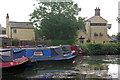
9
Winding hole on the Cromford Canal, Langley Mill
ECP&DA moorings and a winding hole for boats visiting Langley Mill. The Cromford Canal opened in 1794, mostly to carry coal. Most of the canal was abandoned in 1994 and all of it in 1962. This section was restored by ECP&DA during 1972-3, to serve as moorings at the top of the Erewash Canal.
Image: © Christine Johnstone
Taken: 7 May 2019
0.19 miles
10
Visitor moorings, at Langley Mill on the Cromford Canal
Restored and owned by the Erewash Canal Preservation and Development Association. Just north of the junction with the Nottingham Canal.
Image: © Christine Johnstone
Taken: 13 Nov 2017
0.19 miles