IMAGES TAKEN NEAR TO
Brunel Avenue, NOTTINGHAM, NG16 3RE
Introduction
This page details the photographs taken nearby to Brunel Avenue, NG16 3RE by members of the Geograph project.
The Geograph project started in 2005 with the aim of publishing, organising and preserving representative images for every square kilometre of Great Britain, Ireland and the Isle of Man.

There are currently over 7.5m images from over14,400 individuals and you can help contribute to the project by visiting https://www.geograph.org.uk
Image Map
Images are licensed for reuse under creativecommons.org/licenses/by-sa/2.0
Notes
- Clicking on the map will re-center to the selected point.
- The higher the marker number, the further away the image location is from the centre of the postcode.
Image Listing (28 Images Found)
Images are licensed for reuse under creativecommons.org/licenses/by-sa/2.0
Image
Details
Distance
1
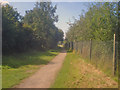
Path from Colliers Wood Country Park
Path west towards Eastwood with the industrial park over the fence on the right. Houses on Brunel Road just visible at the end of the path.
Image: © Trevor Rickard
Taken: 10 Sep 2009
0.06 miles
2
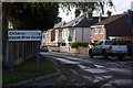
Engine Lane, Eastwood
At this point Engine Lane passes out of the Moorgreen Industrial Park and into a residential area of Eastwood, which no doubt explains the warning about children playing. A height barrier behind the photographer prevents lorries using this route. At one time a mineral railway passed across the road here, giving access to Moorgreen Colliery; the modern house with the 'for sale' board appears to have been built across its former route.
Image: © Stephen McKay
Taken: 15 Nov 2009
0.07 miles
4
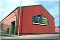
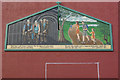
Moorgreen Colliery Industrial Site Memorial
A plaque underneath this mural on one of the original buildings of the former colliery reads "The mural artwork was produced by students of the New College Nottingham Basford Hall in co-operation with Maplebeck Holdings Limited, who have dedicated it to the people of Eastwood. The ceremony was performed by Cllr. Jack Wormall on the 24 September 1999". Two quotations below the pictures are both by D H Lawrence. On the left it reads ".... there was a sort of inner darkness like the gloss of coal in which we moved and had our real being" (1930) and on the right ".... the east was tender with a magenta flush under which the land lay still and rich" (1913). Two contrasting views of the same landscape - the goal on the wall is by local artists unknown!
Image: © Garth Newton
Taken: 31 Aug 2005
0.10 miles
5
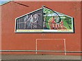
Mural on Engine Lane, Eastwood
This mural faces Engine Lane from the premises of Caunton Engineering, part of the Moorgreen Industrial Park; the building is one of the few that have survived from the old Moorgreen Colliery complex. The mural graphically depicts the change of land use of most of the site, from coal mining to country park, together with quotations from Eastwood's most famous son - D H Lawrence. The trauma of the disappearance of a once great industry on a community such as Eastwood should not be underestimated.
Image: © Stephen McKay
Taken: 15 Nov 2009
0.11 miles
6
Colliers Wood
Colliers Wood, established on the site of the former Moorgreen Colliery, forms part of Nottinghamshire's Greenwood Community Forest. It was created in a restoration scheme in 1996/7, just over ten years after the colliery had ceased production. According to Broxtowe Borough Council, the site will become characteristic of local woodland with sessile oak, birch and alder as well as several other tree species.
Image: © Stephen McKay
Taken: 15 Nov 2009
0.12 miles
7
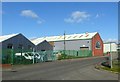
Engineering works, Engine Lane
The brick built section was originally part of the National Coal Board Central Workshops.
Image: © Alan Murray-Rust
Taken: 2 Nov 2018
0.12 miles
8
D H Lawrence mural, Engine Lane
This has suffered some damage since photographed in 2009 https://www.geograph.org.uk/photo/1586069
Image: © Alan Murray-Rust
Taken: 2 Nov 2018
0.12 miles
9
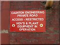
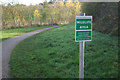
'Private Road' sign
Note however the official public footpath stickers showing that there is still a right of way on foot. See also http://www.geograph.org.uk/photo/5968971 .
Image: © Alan Murray-Rust
Taken: 2 Nov 2018
0.13 miles
10
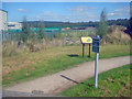
Entrance to Colliers Wood Country Park
View north-east with the industrial estate on the left. Useful information board just inside, detailing what can be seen in the park and some history of Moorgreen Colliery - see Image
Image: © Trevor Rickard
Taken: 10 Sep 2009
0.13 miles