IMAGES TAKEN NEAR TO
Telford Drive, NOTTINGHAM, NG16 3NN
Introduction
This page details the photographs taken nearby to Telford Drive, NG16 3NN by members of the Geograph project.
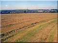
The Geograph project started in 2005 with the aim of publishing, organising and preserving representative images for every square kilometre of Great Britain, Ireland and the Isle of Man.

There are currently over 7.5m images from over14,400 individuals and you can help contribute to the project by visiting https://www.geograph.org.uk
Image Map
Images are licensed for reuse under creativecommons.org/licenses/by-sa/2.0
Notes
- Clicking on the map will re-center to the selected point.
- The higher the marker number, the further away the image location is from the centre of the postcode.
Image Listing (29 Images Found)
Images are licensed for reuse under creativecommons.org/licenses/by-sa/2.0
Image
Details
Distance
1
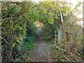
Footpath near Beauvale
Following the trackbed of a former colliery railway line which served a landsale wharf at Newthorpe
Image: © Alan Murray-Rust
Taken: 2 Nov 2018
0.03 miles
2
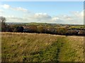
Footpath near Beauvale
The prominent hill left of centre is entirely artificial, being the landscaped former spoil tip of Moorgreen Colliery.
Image: © Alan Murray-Rust
Taken: 2 Nov 2018
0.04 miles
3
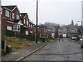
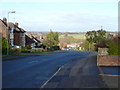
Bosworth Drive
A residential street right on the edge of Eastwood/Newthorpe, built circa 1960s. Partly built on the old site of Moorgreen Colliery and its related workings. The road is short, but tracks an old railway which existed on the site. This railway is now a narrow footpath leading from Mill Road to Engine Lane, passing directly behind the houses on the left.
Image: © Chris Page
Taken: 17 Feb 2010
0.05 miles
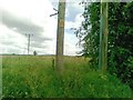
4
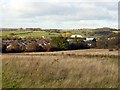
Landscape near Moorgreen
The industrial buildings to the right of the view are on the site of the former Moorgreen Colliery. The curving hedge at the bottom of the field follows the track of a railway siding associated with the colliery.
Image: © Alan Murray-Rust
Taken: 2 Nov 2018
0.07 miles
7
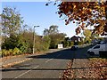
Brunel Avenue, Beauvale
Modern housing estate road, which supplants a former footpath, still shown on OS maps, but passing through several houses!
Image: © Alan Murray-Rust
Taken: 2 Nov 2018
0.18 miles
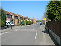
9
Late hay field near Colliers Wood - 2
Looking north-west to the houses on Brunel Avenue. In the distance the hill at Mill Farm near Brinsley.
Image: © Trevor Rickard
Taken: 10 Sep 2009
0.21 miles
10
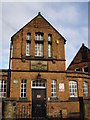
Greasley Beauvale School
The plaque over the main door says: "Greasley Board Schools Erected 1878", and the small aluminium plaque to the top left of the narrow window on the left of the door says: "D. H. Lawrence was a pupil here 1893 - 1898".
Image: © Oxymoron
Taken: 7 Nov 2008
0.21 miles