IMAGES TAKEN NEAR TO
Farrington Way, NOTTINGHAM, NG16 3AG
Introduction
This page details the photographs taken nearby to Farrington Way, NG16 3AG by members of the Geograph project.
The Geograph project started in 2005 with the aim of publishing, organising and preserving representative images for every square kilometre of Great Britain, Ireland and the Isle of Man.

There are currently over 7.5m images from over14,400 individuals and you can help contribute to the project by visiting https://www.geograph.org.uk
Image Map
Images are licensed for reuse under creativecommons.org/licenses/by-sa/2.0
Notes
- Clicking on the map will re-center to the selected point.
- The higher the marker number, the further away the image location is from the centre of the postcode.
Image Listing (26 Images Found)
Images are licensed for reuse under creativecommons.org/licenses/by-sa/2.0
Image
Details
Distance
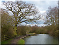
2

Looking across the canal
Sitting in the middle one of the three pollarded trees is a figure that looks as though it is from a fair ground. Quite why it is in the tree is anyone's guess.
Image: © Malcolm Neal
Taken: 18 Sep 2019
0.14 miles
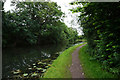
4
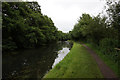
Nottingham Canal, north of Tinsley Road
A public footpath and traffic-free cycle route follow the line of the towpath.
Image: © Christine Johnstone
Taken: 21 Jun 2019
0.17 miles
5
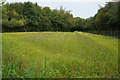
A planted meadow
This open space came as a big surprise as there were many dwarf sunflowers and a range of grasses in this area of the disused Nottingham Canal.
Image: © Malcolm Neal
Taken: 18 Sep 2019
0.18 miles
6
Tree along the towpath of the Erewash Canal
This stretch of the canal is between bridges 26 and 27.
Image: © Mat Fascione
Taken: 28 Feb 2016
0.18 miles
7

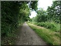
Frosty path west of Eastwood
This footpath, along the course of the long closed Nottingham Canal, was largely frost free when I visited, with the notable exception of this very visible section.
Image: © Richard Vince
Taken: 13 Dec 2014
0.19 miles
9
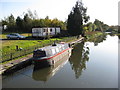
Erewash Canal - View from Anchor Road
Image: © Alan Heardman
Taken: 29 Oct 2008
0.21 miles
10
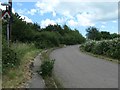
Barrier on Tinsley Road, New Eastwood
Originally this was Bridge Street, with bridges across both the Nottingham and Erewash Canals and a railway. The name probably changed when the A610 was built on the former railway line, and this road bent round slightly to accommodate it.
Image: © Christine Johnstone
Taken: 21 Jun 2019
0.21 miles