IMAGES TAKEN NEAR TO
Alton Drive, NOTTINGHAM, NG16 2WN
Introduction
This page details the photographs taken nearby to Alton Drive, NG16 2WN by members of the Geograph project.
The Geograph project started in 2005 with the aim of publishing, organising and preserving representative images for every square kilometre of Great Britain, Ireland and the Isle of Man.

There are currently over 7.5m images from over14,400 individuals and you can help contribute to the project by visiting https://www.geograph.org.uk
Image Map
Images are licensed for reuse under creativecommons.org/licenses/by-sa/2.0
Notes
- Clicking on the map will re-center to the selected point.
- The higher the marker number, the further away the image location is from the centre of the postcode.
Image Listing (18 Images Found)
Images are licensed for reuse under creativecommons.org/licenses/by-sa/2.0
Image
Details
Distance
1
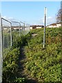
Footpath near Acorn Avenue, Giltbrook
Official notices state that this section of footpath is subject to a closure notice due to the development to the left, but it is clearly still in regular use.
Image: © Alan Murray-Rust
Taken: 2 Nov 2018
0.06 miles
2
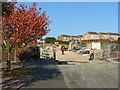
Acorn Avenue, Giltbrook
Housing development under construction on what was previously rather scrubby land will join the currently separated ends of Acorn Avenue.
Image: © Alan Murray-Rust
Taken: 2 Nov 2018
0.06 miles
3

Footpath near Giltbrook Green
The notice is one of several warning against trespassing onto the land off the footpath, which is a public right of way.
Image: © Alan Murray-Rust
Taken: 2 Nov 2018
0.11 miles
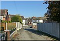
4

Footpath through a housing estate
The original alignment of a long-standing right of way has been maintained as housing estates expanded.
Image: © Alan Murray-Rust
Taken: 2 Nov 2018
0.13 miles
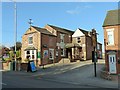
5
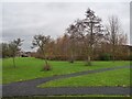
Smithurst Meadows
A local nature reserve in Giltbrook
Image: © Graham Hogg
Taken: 13 Dec 2021
0.14 miles
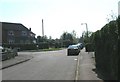
7
Lane off Nottingham Road, Giltbrook
This originally provided access to an old shaft of Newthorpe Colliery and a brickyard, later becoming a public footpath. It now provides access to some modern houses.
Image: © Alan Murray-Rust
Taken: 2 Nov 2018
0.20 miles
8
Ghost sign
Pointing the way to 'Gilbrook Dyers and Cleaners' whose premises were to the left of the sign but have now moved to Ilkeston.
Image: © Graham Hogg
Taken: 13 Dec 2021
0.21 miles
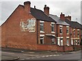
9
The Hayloft, Gilbrook
Formerly the White Bull Inn, which maps indicate has expanded to incorporate what were originally attached cottages.
Image: © Alan Murray-Rust
Taken: 2 Nov 2018
0.21 miles
10
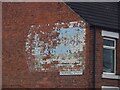
Giltbrook Dyers and Cleaners
Ghost sign on a gable end on Cromwell Street. The sign was pointing the way to their premises but the company has moved and is now located in Ilkeston. Local knowledge from a walking colleague assisted in deciphering the wording.
For context see Image
Image: © Graham Hogg
Taken: 13 Dec 2021
0.21 miles