IMAGES TAKEN NEAR TO
Hawthorne Rise, NOTTINGHAM, NG16 2RG
Introduction
This page details the photographs taken nearby to Hawthorne Rise, NG16 2RG by members of the Geograph project.
The Geograph project started in 2005 with the aim of publishing, organising and preserving representative images for every square kilometre of Great Britain, Ireland and the Isle of Man.

There are currently over 7.5m images from over14,400 individuals and you can help contribute to the project by visiting https://www.geograph.org.uk
Image Map
Images are licensed for reuse under creativecommons.org/licenses/by-sa/2.0
Notes
- Clicking on the map will re-center to the selected point.
- The higher the marker number, the further away the image location is from the centre of the postcode.
Image Listing (39 Images Found)
Images are licensed for reuse under creativecommons.org/licenses/by-sa/2.0
Image
Details
Distance
1
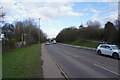
Shilo Way
This is further along Shilo way from the previous submission Image The official designation for the road is the A6096.
Image: © Malcolm Neal
Taken: 10 Feb 2022
0.18 miles
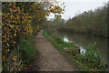
2
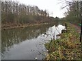
The Nottingham Canal in Awsworth
This section of the canal still in water but little remains of the canal north of here, it having been mostly destroyed by open cast mining.
Image: © Graham Hogg
Taken: 13 Dec 2021
0.18 miles
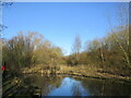
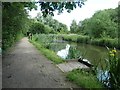
3

The end of the Nottingham Canal
The Nottingham Canal is mostly filled in. In this area it is used for fishermen with many square platforms being provided for access to the water. Two of which can be seen in this view.
Image: © Malcolm Neal
Taken: 18 Jan 2022
0.18 miles
5
The northern end of the watered section of the Nottingham Canal
Image: © Jonathan Thacker
Taken: 10 Feb 2022
0.19 miles
6
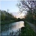
Sunset on the Nottingham Canal
The stretch near Awsworth has been improved as a fishery. The path is part of the Erewash Valley Trail.
Image: © Alan Murray-Rust
Taken: 12 Nov 2018
0.19 miles
7
The former Nottingham Canal disappears
The northern end of the stretch fished by Awsworth Angling Club.
Image: © Christine Johnstone
Taken: 21 Jun 2019
0.19 miles
8
Nottingham Canal towpath
Access is available to the towpath here from the Awsworth by-pass; the remains of the canal are on the left in this view but overgrown - there is open water a little further along. The sign ahead says 'no night fishing'.
Image: © Stephen McKay
Taken: 16 Nov 2014
0.20 miles
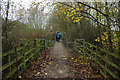
9

Footpath onto former Nottingham Canal towpath
The path leads from the A6096, across the former route of the canal and on to Bennerley Viaduct (behind the photographer).
Image: © David Martin
Taken: 10 Apr 2023
0.20 miles
10
Nottingham Canal, Awsworth
A stretch of the disused canal running parallel with the Awsworth by-pass.
Image: © Stephen McKay
Taken: 16 Nov 2014
0.20 miles