IMAGES TAKEN NEAR TO
Spring Hill, NOTTINGHAM, NG16 2PF
Introduction
This page details the photographs taken nearby to Spring Hill, NG16 2PF by members of the Geograph project.
The Geograph project started in 2005 with the aim of publishing, organising and preserving representative images for every square kilometre of Great Britain, Ireland and the Isle of Man.

There are currently over 7.5m images from over14,400 individuals and you can help contribute to the project by visiting https://www.geograph.org.uk
Image Map
Images are licensed for reuse under creativecommons.org/licenses/by-sa/2.0
Notes
- Clicking on the map will re-center to the selected point.
- The higher the marker number, the further away the image location is from the centre of the postcode.
Image Listing (49 Images Found)
Images are licensed for reuse under creativecommons.org/licenses/by-sa/2.0
Image
Details
Distance
1
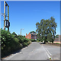
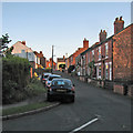
Swingate: Spring Hill
There are hundreds of three-storey terraces like these in Nottingham's inner suburbs. They look rather out of place all alone here on a lane backed by fields.
Image: © John Sutton
Taken: 26 Jun 2018
0.00 miles
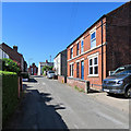
2
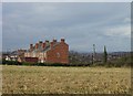
Spring Hill, Swingate
An somewhat isolated Victorian terrace, clearly built speculatively on available land which never became fully joined up to the main development.
Image: © Alan Murray-Rust
Taken: 11 Nov 2007
0.01 miles
3
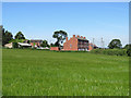
Swingate: barley at Spring Hill
There are hundreds of three-storey terraces like these in Nottingham's inner suburbs. They look rather out of place next to a barley field.
Image: © John Sutton
Taken: 26 Jun 2018
0.01 miles
4
The Robin Hood Way at the back of Little Lane, Swingate
Image: © Alan Murray-Rust
Taken: 11 Nov 2007
0.06 miles
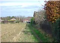
5
Swingate: up Little Lane
Quarter to nine on a lovely July evening.
Image: © John Sutton
Taken: 5 Jul 2016
0.10 miles
6
Swingate: up Little Lane
Looking towards Spring Hill on a hot June morning.
Image: © John Sutton
Taken: 26 Jun 2018
0.10 miles
7
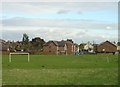
Playing fields, Swingate
North Street Swingate is in the background
Image: © Alan Murray-Rust
Taken: 11 Nov 2007
0.11 miles
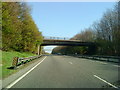
9
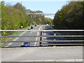
View of footbridge over A610 from Swingate bridge
View from Swingate bridge looking towards M1 junction 26 towards Nottingham
Image: © Neil Robinson
Taken: 18 Apr 2015
0.15 miles
10
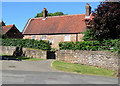
Kimberley: Manor Farm
Grade II listed, its pantiles, local stone and casements looking to date from the 18th century - but it is a century earlier and sandstone and brick conceal a timber frame.
Image: © John Sutton
Taken: 26 Jun 2018
0.16 miles