IMAGES TAKEN NEAR TO
High Street, NOTTINGHAM, NG16 2PD
Introduction
This page details the photographs taken nearby to High Street, NG16 2PD by members of the Geograph project.
The Geograph project started in 2005 with the aim of publishing, organising and preserving representative images for every square kilometre of Great Britain, Ireland and the Isle of Man.

There are currently over 7.5m images from over14,400 individuals and you can help contribute to the project by visiting https://www.geograph.org.uk
Image Map
Images are licensed for reuse under creativecommons.org/licenses/by-sa/2.0
Notes
- Clicking on the map will re-center to the selected point.
- The higher the marker number, the further away the image location is from the centre of the postcode.
Image Listing (63 Images Found)
Images are licensed for reuse under creativecommons.org/licenses/by-sa/2.0
Image
Details
Distance
1
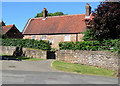
Kimberley: Manor Farm
Grade II listed, its pantiles, local stone and casements looking to date from the 18th century - but it is a century earlier and sandstone and brick conceal a timber frame.
Image: © John Sutton
Taken: 26 Jun 2018
0.02 miles
2
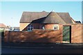
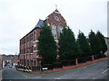
Side of Cherubs Day Nursery
A Victorian era school I think. An interesting round off-shoot.
Image: © David Lally
Taken: 1 Dec 2020
0.05 miles
3
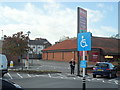
Retail park, Kimberley
Note the blood red berries of the Rowan tree to the left of the photo.
Image: © nick macneill
Taken: 12 Sep 2011
0.07 miles
4
Kimberley: Chapter Drive and the Cemetery
A view taken against the light on a lovely June morning.
Image: © John Sutton
Taken: 26 Jun 2018
0.08 miles
5
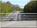
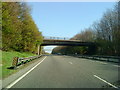
View of footbridge over A610 from Swingate bridge
View from Swingate bridge looking towards M1 junction 26 towards Nottingham
Image: © Neil Robinson
Taken: 18 Apr 2015
0.09 miles
7
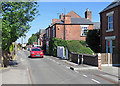
Kimberley: High Street
A bright morning in late June.
Image: © John Sutton
Taken: 26 Jun 2018
0.09 miles
8
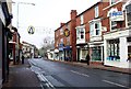
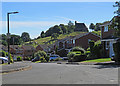
Main Street, Kimberley
The main road through the town. Humming with activity at 10:30 on a Wednesday morning. Certainly used to be busy, but since S****bury's was built 200 yards up the road about 20 years ago, everyone buzzes round there. The small shops along Main Street constantly change hands or close down - there are at least two empty at present. Very few have kept going all this time.
Image: © Lynne Kirton
Taken: 23 Nov 2005
0.11 miles
9
St Paul's Court, High Street, Kimberley
Formerly a Methodist? church (date stone 1884), now flats.
Image: © Tim Heaton
Taken: 29 Dec 2008
0.12 miles
10
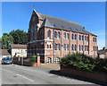
Kimberley: former Methodist Church
Originally St Paul's Methodist Church but now in residential use, on the corner of High Street and James Street. For more about it, try http://kimberleynow.com/wp-content/uploads/2015/02/KHT-Full-Booklet-Low-Res.pdf . Image] is another view of it.
Image: © John Sutton
Taken: 26 Jun 2018
0.12 miles