IMAGES TAKEN NEAR TO
Broomhill Road, NOTTINGHAM, NG16 2LZ
Introduction
This page details the photographs taken nearby to Broomhill Road, NG16 2LZ by members of the Geograph project.
The Geograph project started in 2005 with the aim of publishing, organising and preserving representative images for every square kilometre of Great Britain, Ireland and the Isle of Man.

There are currently over 7.5m images from over14,400 individuals and you can help contribute to the project by visiting https://www.geograph.org.uk
Image Map
Images are licensed for reuse under creativecommons.org/licenses/by-sa/2.0
Notes
- Clicking on the map will re-center to the selected point.
- The higher the marker number, the further away the image location is from the centre of the postcode.
Image Listing (60 Images Found)
Images are licensed for reuse under creativecommons.org/licenses/by-sa/2.0
Image
Details
Distance
1
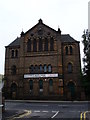
United Methodist Free Church, Kimberley
Now apparently hosting a reprographics company.
Image: © Oxymoron
Taken: 30 Aug 2008
0.05 miles
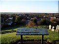
2
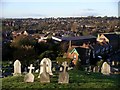
Kimberley from the cemetery
Being on top of a hill in the middle of Kimberley, the cemetery commands a wide-ranging view across the town and beyond. The large, grey-roofed building in the centre of this picture is Sainsbury's, which dominates the town. Sainsbury's is built on the site of the old Wolsey factory. The road leading to Sainsbury's used to be called Factory Lane. However, the name was changed to Greens Lane when the supermarket and adjacent shopping precinct were completed, presumably because the old name no longer reflected the newly renovated area.
Image: © Lynne Kirton
Taken: 13 Nov 2010
0.05 miles
3
Kimberley Cemetery and Chapel on the Hill
Image: © Chris Morgan
Taken: 14 Mar 2022
0.08 miles
4

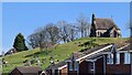
Tree, Kimberley cemetery
This gnarled old tree watches over gravestones in Kimberley cemetery. The cemetery is on a hill in the middle of the town, and so the tree is exposed to the winds which have probably helped to shape it.
Image: © Lynne Kirton
Taken: 13 Nov 2010
0.08 miles


7
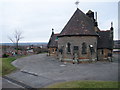
Chapel of rest, Kimberley Cemetery
Atop Knowle Hill, with a good view over the town.
Image: © Tim Heaton
Taken: 29 Dec 2008
0.08 miles
8
Kimberley from the cemetery
The cemetery is perched on a hill in the centre of Kimberley, with wide-ranging views of the town and beyond, especially on a clear day. Beyond the far edge of the cemetery can be seen the local Sainsbury's, built on the site of the old Wolsey factory. Kimberley is mentioned in the Domesday Survey of 1086 as "Chinemarelie". The hills on the horizon are in Derbyshire.
Image: © Lynne Kirton
Taken: 13 Nov 2010
0.08 miles
9
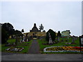
Kimberley Cemetery (2)
This is visually rather impressive, with the chapel sitting on a small mound in the centre of the cemetery - pity it's tucked away down a side road.
Image: © Oxymoron
Taken: 30 Aug 2008
0.08 miles
10
Kimberley Cemetery
This is visually rather impressive, with the chapel sitting on a small mound in the centre of the cemetery - pity it's tucked away down a side road.
Image: © Oxymoron
Taken: 30 Aug 2008
0.08 miles