IMAGES TAKEN NEAR TO
Sidney Street, NOTTINGHAM, NG16 2LQ
Introduction
This page details the photographs taken nearby to Sidney Street, NG16 2LQ by members of the Geograph project.
The Geograph project started in 2005 with the aim of publishing, organising and preserving representative images for every square kilometre of Great Britain, Ireland and the Isle of Man.

There are currently over 7.5m images from over14,400 individuals and you can help contribute to the project by visiting https://www.geograph.org.uk
Image Map
Images are licensed for reuse under creativecommons.org/licenses/by-sa/2.0
Notes
- Clicking on the map will re-center to the selected point.
- The higher the marker number, the further away the image location is from the centre of the postcode.
Image Listing (69 Images Found)
Images are licensed for reuse under creativecommons.org/licenses/by-sa/2.0
Image
Details
Distance
1
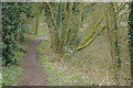
Great Northern Railway Path
At one time Kimberley had two railways. The former Great Northern line between Nottingham and Derby outlasted the old Midland route but was in the end a casualty of the Beeching era, closing to passengers in 1964 and completely four years later. Here the old trackbed has been converted into a path and access is available from Church Hill. The British Transport Commission style station sign advertises the path's presence.
Image: © Stephen McKay
Taken: 11 Mar 2018
0.05 miles
2
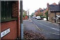
High Street, Kimberley
Not the main road through the town, as one might suppose, but runs parallel to Main Street at a higher level. Literally a high street!
Image: © Lynne Kirton
Taken: 23 Nov 2005
0.07 miles
3
Great Northern Railway Path
At one time Kimberley had two railways. The former Great Northern line between Nottingham and Derby outlasted the old Midland route but was in the end a casualty of the Beeching era, closing to passengers in 1964 and completely four years later. Here the old trackbed has been converted into a path and access is available from Church Hill.
Image: © Stephen McKay
Taken: 11 Mar 2018
0.08 miles
4
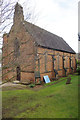
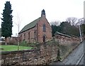
Kimberley Church
Holy Trinity Church on Church Hill was consecrated in 1847 at a time when the population of the area was rapidly expanding. Kimberley, although an ancient settlement mentioned in the Domesday Book (as Chinemarelie), was a part of the parish of Greasley and the original intention was that the new building should act as a chapel of ease to Greasley Church. Kimberley became a parish in 1851, albeit with a curate in charge and an arrangement under which ecclesiastical fees were retained by the vicar of Greasley until the end of his incumbency, which occurred in 1866. More recently, the church underwent a major restoration in 1937.
Image: © Stephen McKay
Taken: 11 Mar 2018
0.08 miles
5
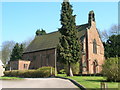
Church of the Holy Trinity, Kimberley
Parish church built in 1847
Image: © Tim Heaton
Taken: 28 Dec 2008
0.08 miles
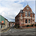
6
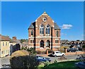
Former St Paul's Methodist Church, Kimberley
Image: © Chris Morgan
Taken: 14 Mar 2022
0.09 miles
7
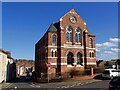
St Paul's Court
The former St Paul's Methodist Church has been converted to residential use.
Image: © Graham Hogg
Taken: 14 Mar 2022
0.09 miles
9
Kimberley: St Paul's Court
Originally St Paul's Methodist Church but now in residential use, on the corner of High Street and James Street. For more about it, try http://kimberleynow.com/wp-content/uploads/2015/02/KHT-Full-Booklet-Low-Res.pdf . Some unpleasant conifers have been removed since Tim Heaton was here in 2008: Image
Image: © John Sutton
Taken: 8 Sep 2017
0.09 miles
10
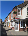
Kimberley: up James Street
Pretty hanging baskets, Italian and Chinese restaurants and a bright blue sky on a June morning.
Image: © John Sutton
Taken: 26 Jun 2018
0.09 miles