IMAGES TAKEN NEAR TO
Alma Hill, NOTTINGHAM, NG16 2JH
Introduction
This page details the photographs taken nearby to Alma Hill, NG16 2JH by members of the Geograph project.
The Geograph project started in 2005 with the aim of publishing, organising and preserving representative images for every square kilometre of Great Britain, Ireland and the Isle of Man.

There are currently over 7.5m images from over14,400 individuals and you can help contribute to the project by visiting https://www.geograph.org.uk
Image Map
Images are licensed for reuse under creativecommons.org/licenses/by-sa/2.0
Notes
- Clicking on the map will re-center to the selected point.
- The higher the marker number, the further away the image location is from the centre of the postcode.
Image Listing (7 Images Found)
Images are licensed for reuse under creativecommons.org/licenses/by-sa/2.0
Image
Details
Distance
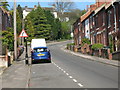
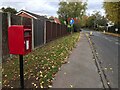
1
Maws Lane, Kimberley
Maws Lane at its junction with Cornfield Road; Maws Lane Co-op's car park is to the left.
Image: © Stephen McKay
Taken: 11 Mar 2018
0.06 miles
2
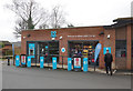
Maws Lane Co-op, Kimberley
This Co-op convenience store opened in September 2016; road access to the car park is via Cornfield Road.
Image: © Stephen McKay
Taken: 11 Mar 2018
0.09 miles
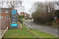
5
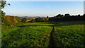
On the Robin Hood Way northwest of Kimberley
Image: © Colin Park
Taken: 8 Sep 2021
0.23 miles
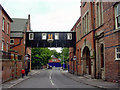
6
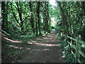
Woodland Footpath, Kimberley
A short footpath (Johnny's Hill) through woodland linking Oak Lodge Drive (Hardy Street) with the playground and park on Eastwood Road.
Image: © Sue Adair
Taken: 27 May 2012
0.24 miles